|
Three major rivers in England are named Ouse. The word Ouse comes from the Sanskrit for water. The Great Ouse stretches from the East Midlands to the Wash. The Rivers Swale and Ure in Yorkshire converge to form the Yorkshire Ouse. The Sussex Ouse is a 50 kilometres (30 miles) river that rises near Horsham, passes Lewes, and then empties into the English Channel at Newhaven.
Yorkshire Ouse(Derwent, Swale , Ure, Wharfe and Nidd ) The River Ouse is formed from the joining of the Rivers Swale and Ure to the east of Knaresborough. The Nidd, which flows through Knaresborough, enters the Ouse a little farther downriver. In this way the Ouse gathers a large amount of water in a short distance. All of the headwaters drain from the Pennines and so can carry large amounts of water. However, because the water is in steep-sided valleys, the amount of flooding that can occur is limited. When the rivers join to make the Ouse, however, they flow over the almost flat Vale of York and so the much more meandering course of the river over this low lying landscape is much more likely to give frequent and severe flooding. The Wharfe flows into the Ouse down river of York, swelling the river even more with yet another Pennine river. This makes the town of Selby, like York, very prone to flooding. Defenses have been built for many years to try to reduce the amount of flooding and the Ouse is lined with embankments known as levees. However, these flood defenses can only be of a certain height and can still be overtopped, as happened in the November 2000 floods. The large size of the Ouse and the long distance that boats could get inland using the river for transport, meant that the Ouse has long been an important commercial river, making York an significant Roman and medieval port. The Ouse joins the Trent to form the River Humber.
Places on the Ouse system
YorkYork was built where the River Foss joins the Ouse. The site was first chosen by the Romans, who built a fort in the angle made by the join of the rivers in AD71. This was called Eboracum. The site continued to thrive and became an important town for the Vikings. It was they who called the city Yorvick and this is how the city eventually became known as York. When the Normans took control of York at the end of the 11th century, they were very anxious to make the city even more secure. To this end they built two castles, enlarged and rebuilt the city wall, and built a moat around the outside of the city. The castles were built on land constructed higher up than the flat plain (they were known as motte and bailey castles).

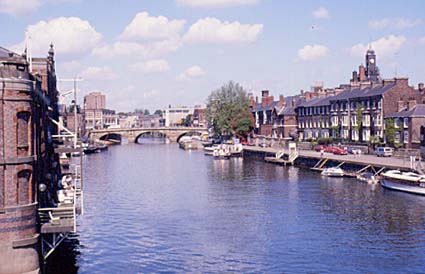
The River Ouse at York.Through all of this time the River Ouse was both a blessing and a curse. The river was navigable and so allowed the city to prosper as a port. The ease with which the city could be surrounded by water was good for defense. But the city was regularly flooded as the headwaters discharged huge amounts of Pennine water into the lowland around York each winter. As the city grew through the Industrial Revolution and to modern times, the need for more housing has grown and the city has sprawled across the river. As a result, the need for stronger and stronger flood defenses has been important for many decades. The latest flood defenses, combined with the building of reservoirs on the headwaters to slow down the flood waves, were able to hold through the November 2000 floods which affected the Ouse elsewhere, even though the river level was the highest for over a century.
KnaresboroughKnaresborough is an ancient market town that occupies a dramatic site on the outside bend of a meander in the River Nidd on the edge of the Vale of York. The cliff is made of hard cavernous limestone and it has given its name to the town: Knare is old Viking for craggy rock and borough is Anglo-Saxon for a fortified site. This is a very ancient site, but what survives dates from the 11th century when a Norman castle was built on the crag and a New Town laid out beside it. The town still shows the same medieval street plan that was laid out at this time. It was protected by an earth rampart and a ditch. The growth of Knaresborough began with the market and also the use of the river as a source of power. Fulling mills were built on the river, whose water-powered hammers made woollen cloth more bulky, or fuller. From the 17th century water powered linen mills were also built by the river. But in fact the coming of coal power stopped the growth of industry in its tracks and new mills were built on distant coalfields. When the railway (and its ability to transport coal) finally came to Knaresborough and the engineers built a magnificent stone bridge over the river, it was already too late for development. As a result Knaresborough has remained a charming riverside town unspoiled by industrialisation that has come to so much of the rest of the West Riding of Yorkshire. The Dropping Well is a spring whose natural mineral content is so high that it 'petrifies' objects left in its waters.

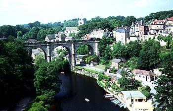
The River Nidd, running in a gorge at Knaresborough. This picture is looking north from the Norman castle across the 19th century stone railway bridge.
Sussex OuseThe Sussex Ouse is a short river. It flows from Horsham in the Ashdown Forest to the sea at Newhaven. To understand why it flows across the 'grain' of the country, and why it cuts through the high chalk hills of the South Downs see the explanation under River Arun. Much of the headwaters of the Ouse run over infertile sandy soils, so most of the land is little cultivated and remains as forest. The main town is Lewes, which lies just by the gap cut in the South Downs. Like Arundel castle on the Arun, Lewes Castle was built to defend a route through the downs by possible invaders landing on the south coast. In the 17th century Daniel Defoe described Lewes as 'in the most romantic situation I ever saw'. Today the busiest place on the river is Newhaven. Here the estuary of the Ouse is used as a sheltered harbour, and until recently a terminus for the cross channel ferries to Dieppe in France. |