|
Derwent is a common river name. Here are some examples:
RIVER DERWENT, NORTH YORKSHIREThe River Derwent is a tributary of the River Ouse and then the River Trent. Tributaries include: Dove, Hertford, Riccat. Rye, and Seven The River Derwent gathers many of the southward-flowing tributaries of the North York Moors including the Rivers Dove, Riccat, Rye, and Seven. Each of these tributary rivers flows off the flanks of the Moors, following the natural southward dip of the land. The North York Moors are made of layers of sandstone and gritstone, interbedded with shale and limestone. The high moors are dominated by grit. The headwaters of the rivers begin broad and shallow because of the difficulty of cutting down through the gritstone. The headwaters drain vast areas of peat, which acts like a sponge, soaking up rainfall and then releasing it slowly into the rivers throughout the year. As the tributaries gather more water they begin to cut down deeply into the moors, creating steep-sided valleys called dales. The dales are steep sided and narrow. Between them are areas of undissected moorland. Given a choice between ease of travel across the moors and the much more difficult travel beside the rivers in the narrow dales, people in the past chose to travel on the moors, keeping clear of the dales. The Romans were the first to avoid the river valleys (dales), as shown by the remains of their road over Wheeldale Moor. The main road from Pickering to Whitby and the high road from Hutton-le-Hole to Castleton were similarly directed away from the dales. Unusually, therefore, the main roads offer beautiful views of the dales, rather than, as is more usual, following the rivers and only offering views up to the hills. Only those who sought to be remote and chose to live on the moors found the shelter of the dales useful. Among the most well known of these early settlements were those created by the monks who built Rosedale Abbey on the River Seven in the bottom of Rosedale and Rievaulx, on the River Rye in Bilsdale. In these two spots very little farming could be achieved and these abbeys survived on money gained from farmland they owned elsewhere. Few others without these resources could live in this unproductive area. The North York Moors were not covered with ice during the Ice Age. Instead, ice swept around the moors and trapped rivers and their waters. Huge lakes built up on the sides of the ice sheet. As waters drained from these lakes (sometimes around the edge of the ice, sometimes underneath it), so they cut channels across the landscape. Many of these channels are now dry (or peat filled) because they were only useful while the ice still trapped the rivers on the moors. The largest of these ancient channels is Newtondale, whose tiny river flows in a vast peat-lined trench from the moors down to Pickering. As the tributaries flow in their deep dales toward the flat-floored Vale of Pickering, they begin to change character, following more meandering paths. This is because they are using less energy cutting down and are able to devote some of it to widening their floodplains. The junction between the dales and the Vale of Pickering is marked by a line of small villages and the towns of Helmsley and Pickering. These are connected together by the road from Scarborough to Thirsk. This marks the edge of the former fenland and former lake (Lake Pickering) which existed in glacial times. The lake drained at the end of the Ice Age, but the fenland remained impenetrable for many thousands of years and was only reclaimed with effort. The River Derwent is the dominant river across the vale, collecting a whole string of tributaries from the moors as it flows to Norton. This curious river begins by flowing southeastward from the North York Moors, gets within a few kilometres of the North Sea and then veers abruptly westward across the floor of the Vale of Pickering. Its strange course is due to the fact that the eastward route that it followed before the Ice Age was blocked during the Ice Age, first by the ice and then by a great natural dam deposited by the ice. This dam, on which the landward suburbs of Scarborough are built, is called a terminal moraine. The Hertford River, which rises near Filey, is similarly diverted to flow west. As all the rivers gather together and flow south, so they flow through a gorge in the limestone, Howardian Hills. This strange gorge is yet another feature of the Ice Age, for when the ice blocked the outlet of the Derwent and Hertford rivers, so it created Lake Pickering, which ponded back across the Vale of Pickering as far as Helmsley. The waters of this vast lake had to find an outlet somewhere, and they could not flow north because the North York Moors are too high. Instead they flowed south across the lower Howardian range of hills. As the lake drained south, so its waters carved a channel - now the gorge in which the Derwent flows. The gorge is at Kirkham and here, as on the North York Moors, in a remote and beautiful area, lies another riverside abbey - Kirkham Abbey. South of the Howardian Hills, the Derwent flows across the eastern part of the Vale of York. It is now a lowland river again, with sweeping meander bends. Finally, it joins the Ouse, just before that river enters the Trent and then flows to the North Sea.
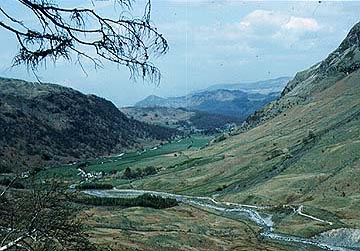
RIVER DERWENT, LAKE DISTRICTThe River Derwent has its headwaters on the highest flanks of the lake District mountains, close to Great End and Scafell Pike. The Derwent drains part of the northward slopes from the core of the Lake District, tumbling down its highland valley and spilling over ledges of hard rock to make waterfalls, including Galleny Force, before reaching Borrowdale. Another headwater flows down from Sty Head, over Taylorgill Force to run under Stockley Bridge and down to the farm at Seathwaite.
Seathwaite in Borrowdale.
At Borrowdale, both headwaters unite and, still carrying silt and, in flood, pebbles and boulders, flow across the flat-floored and glacially cut valley flow filled mostly by the lake of Derwentwater.
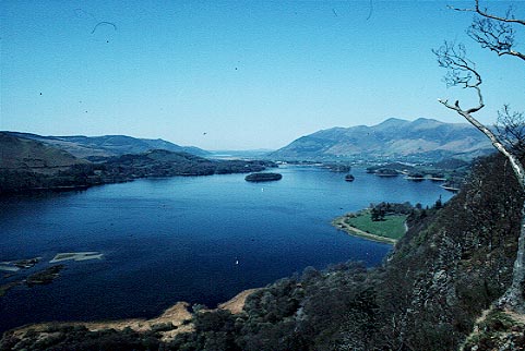
Derwentwater looking northwest.The lake lies in Borrowdale, one of the great glacially-scoured valleys of the Lake District. The Derwent spills into the southern end of the lake, gradually building out a delta into the lake. In time, the lake will be filled in by silt brought by the river. For the moment, however, it forms one of the largest of the Lake District lakes. At the northern end of Derwentwater, near Keswick, the Derwent re-emerges to flow further down the dale until it flows into another great lake - Bassenthwaite.
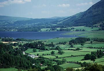
Bassenthwaite Lake.
Then, at the northern end of the lake the Derwent re-emerges as a river again, but this time on the lowland coastal plain of Cumbria, a hummocky landscape covered in the debris from a former ice sheet. Here the Derwent meanders in broad loops past the market town of Cockermouth and then on to the sea at the industrial port of Workington. Tributaries include: Dove, Hertford, Riccat. Rye, and Seven The River Derwent gathers many of the southward-flowing tributaries.
RIVER DERWENT, DERBYSHIRETributaries include the Rivers Ashop, Noe and Wye The 'Derby' Derwent is a tributary of the River Trent The Derwent, which, unusually for a Pennine river, flows south rather than east or west, has its headwaters on the Yorkshire Pennines to the west of Sheffield. Here, on Howden Moors, the many headwaters drain great thicknesses of upland peat bog. As the tributaries gather, so they cut into the landscape and create deep valleys, ideal places to dam and create reservoirs for the needs of nearby cities like Sheffield. The waters of the Derwent are captured by a whole string of reservoirs: Howden Reservoir, Derwent Reservoir and the Ladybower Reservoir.
Derby grew up on the Derwent because the water could be used for the textile industry. One of the oldest textile mills in the country is now used as a museum (the building with the tower on the left).
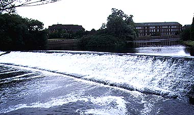
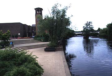
The civic offices and weir at Derby.The southward course of the Derwent is due to the way that the river follows a band of mostly soft, watertight, muddy rocks called the Yoredale Beds. They are sandwiched between the mountain limestone which form the higher ground of the High Peak to the west, and the high ridges of hard Millstone Grit to the east. The Derwent receives hardly any tributaries from the east, although it is joined by several tributaries from the limestone areas to the west. The largest of these is the Wye, at a crossing point of which lies the market town of Bakewell (famous for its puddings). The headwaters of the Wye also include the well known limestone area of Castleton and the valley of Edale. Near Castleton is the hill of Mam Tor, where great landslips in the shale rocks have created a massive scar.
The Peak District is an area famous for its mountain limestone. This hard, light gray rock weathers into large blocks. Some layers of the limestone are harder, or the blocks larger, than others, and these tend to make cliffs, or scars, while the smaller blocked limestone makes less steep parts of the slopes. The dryness of the higher dales is not entirely natural and some are dry throughout the year. This is because of extensive mining which took place in the 18th century. At this time tunnels were drilled into the limestone to drain it and so make the lead mines dry and easier to work. The Derwent flows from Yorkshire, south to Derbyshire, following a deep valley with many famous landscape features such as Padley Gorge. It is also overlooked by the stately homes of Chatsworth House and Haddon Hall. At Rowsley, the valley changes shape completely, no longer steep-sided and narrow, but broad. Then, just above the spa town of Matlock, it narrows into a gorge again, this time cut directly into an eastward projection of the mountain limestone. The most prominent overlook at this point is High Tor. It is not until the river reaches Cromford that it returns to the soft Yoredale rock and broadens out again. Cromford was the site of the world's first factory, built by Richard Arkwright. The Arkwright cotton mill has been restored in part and reminds visitors that, in the earliest days of the Industrial Revolution, water power was vital to the siting of factories. Many other mills were built along the Derwent and its tributaries, although none survive like that at Cromford. Cromford is also the starting point of the Cromford Canal - canals being another landmark on the road to industrialization. Below Cromford the river flows away from the Peak District and falls steadily in height and the valley increases dramatically in width. Derby, an ancient market town on a crossing point of the Derwent on the southern edge of the Peak District, was also a textile town. But it succeeded where Cromford eventually failed because barges were able to bring coal to Derby to power the steam engines that replaced the water wheels.
|