|
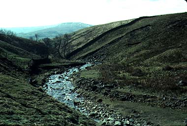
This is the Fossdale Gill at the foot of the suggested field trip. Notice the landslides in the glacial materials that floor the valley.
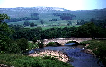
This is the floodplain of the Ure just outside Hawes. Notice the Wensleydale in the background, including the white mountain limestone scars.The River Ure is one of the larger rivers draining off the eastern flanks of the Pennine Hills. The upper Ure begins in the high moorlands of Mallerstang Common, just south of Kirkby Stephen. Here some of the headwaters of the Ure have been lost to the competing River Eden that flows down the shorter, steeper course of the western flanks of the Pennines. This high land is a saddle, or col, in the Pennines, and has long been used as a route to cross from east to west of England. It is still followed by the A684. From the high moors the Ure flows through one of the best known of the Yorkshire valleys - Wensleydale. The wide open Wensleydale is a product of rocks and of past glacial changes. Here the rocks are almost level, a mixture of hard millstone grit, softer Yoredale Beds and hard mountain limestone. The combination gives the sides of the valley a staircase appearance, the hard limestones making the risers, while the softer shales make the treads of the natural staircase. The tributaries of the Ure are especially affected by the difference in rocks. High on Abbotside Common, to the north of the market town of Hawes, the streams flow first over the peat bogs of the Millstone grit, then through a gorge of shales, and then almost disappear as they come to the mountain limestone. Some disappear entirely into swallow holes in the limestone, while others just manage to survive for most of the year provided the water table in the rocks is high enough.
While the valley side tributaries tumble down over the rocks and give some small, but spectacular waterfalls, such as Cotter Force, the main river flows in a wide valley. Here the effects of glaciation have widened the valley and provided deposits on the valley floor that have been reworked by the river into a series of river terraces. These are well seen at Hawes, where many buildings have taken advantage of a slightly higher, flood-proof site. The river meanders over the flat valley floor as it passes east through Hawes and Bainbridge to Aysgarth and Wensley, at which point it leaves the Pennines and flows over the Vale of York. The Vale of York is a geological vale, formed by past folding and faulting of the rocks. Many rivers flow over this broad flat area. The largest settlement on the Ure in this part of the valley is Ripon. From Ripon the river meanders south to join the Swale just up river from York, where the river is renamed the Ouse.
Places on the Ure
BoroughbridgeThis was once the place where the London to Scotland road crossed the Ure. The site is now by-passed by the A1, and close by is one of Britain's largest power plants.
RiponThe cathedral city of Ripon stands by the River Ure.
Field tripTo study the relationship between rock type of river action, try the hillside of Abbotside Moor. This is on the road from Hawes toward Muker via Buttertubs (swallow holes). Go from Hawes up past the old lead mines and find a small parking place next to a stone bridge that takes a tributary stream down to join the Foss Gill, which is one of the headwaters of the Ure. Now follow the stream up onto the moor, across the mountain limestone, higher on to the peatlands of the Yoredale shales, and finally to the fell tops which are Millstone Grit. This provides an excellent introduction to geology as well as geography and numerous corals and other Carboniferous fossils can be found in the limestone. The trip from Fossdale Beck to the fell top is not long, but will take most of a day due to the enormous variety of activities that are possible. Here you will be able to find evidence of swallow holes (just on the slopes away from the stream) and of resurgences (springs). On the Yoredale beds (with their dark brown and black colors) there is a spectacular and largely unknown waterfall, while, below this, the stream meanders and gives opportunities for studying river action. Up toward the Millstone Grit you can get spectacular views over the landscape. Close at hand are the peat bogs that provide the source to the Ure. A whole range of field sketches can be achieved on this tiny stream and it can be visited quite safely for much of the year to see changes between, say, spring and summer when water tables are quite different. Do take sensible mountain walking precautions for the safety of parties because the weather can quickly turn cold and foggy. |