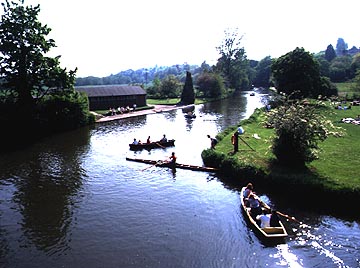
The Wey floodplain narrows as the river goes through the gap in the chalk hills at Guildford. Being just to the south of the city, the land is used for recreation. This is also a canalised part of the river, known as the Wey Navigation. This photograph looks south.The River Wey flows from the high sandstone forests of southern Surrey and east Hampshire northward to join the Thames near Walton on Thames. It is paralleled by the smaller River Mole which reaches the Thames a short distance east of the Wey. The most interesting feature of both of these rivers (and others that run north and south from the Weald of Kent) is that each cuts a deep gap - though not quite a gorge - through the broad east-west trending ridges of sandstone and chalk that make the main hills of South East England. At each gap there lies a town - in the case of the Wey it is Guildford in the single chalk gap, for the Wey it is Dorking in the chalk gap and Leatherhead in the gap in the sandstone ridge. The towns mark very ancient settlement sites for, in the past, people travelled on the dry upland ridges and avoided the marshy lowland vales. So the main routes ran east to west. Only when they came to the gaps of the Wey and the Mole were people forced to descend to the lowland and there cross the rivers. This, of course, proved an ideal spot both for a trading town and also an important place to defend, which is why most gap towns have castles. To know about the origin of these gaps see the description of the River Medway. Like the Medway, the Wey has also been an aggressive river, capturing the headwaters of the Hampshire Blackwater so that the Wey now has headwaters that begin far to the west of the Guildford gap, close to Alton. From Alton the Wey flows east, passing through Farnham (again a town defended by a castle) and then past the garrison town of Aldershot, before turning north at the cathedral city of Guildford. In the days before railway travel, think what opportunities the course of the Wey must have seemed to offer. Here was a route cutting through the high ridges of Surrey and providing a natural routeway from London toward the south coast. Although following the Wey only accomplishes half of this journey, to the south lies the River Arun. Thus the canal engineers of the 18th century planned to use the routes of these rivers to provide a route for carrying coal and other bulky cargoes. Little survives of this ancient canal today except in a section south of Guildford called the River Wey Navigation and the Wey and Arun canal, much of it in the care of the National Trust. PLACES ON THE WEY Aldershot Farnham Guildford Weybridge 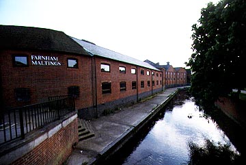
The Maltings at Farnham was just one of many rural industries that sited themselves besides the navigable Wey in the days before rail transport.
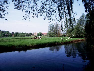
The Wey flows in a wide floodplain near Godalming. The high chances of flooding have meant that this land is still unused. Notice the meadows in the foreground and the houses built on the valley side in the distance.
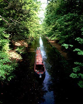
The Basingstoke canal was built to link the Thames to Basingstoke via the Wey Navigation. Parts of it run through leafy cuttings in the sandy heaths to the west of Guildford. |