|
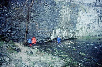
Malham Cove.The River Aire begins on the eastern flanks of the Pennines at the spectacular locations of Malham Tarn and Malham Cove. It then flows in deeply incised Airedale and onto the eastern plains, first past Leeds and then to join the Ouse just before flowing into the Humber and reaching the North Sea. The source of the Aire is in the springs that flow out below the high summit of Pen y Ghent. Malham Tarn survives as a lake in an area of limestone because here there is a patch of boulder clay remaining from the time when glaciers covered this land during the Ice Age. As the Aire flows out of Malham Tarn it quickly disappears down a swallow hole. This was not always the case, and nearby Malham Cove (whose vertical face marks the line of the Craven Fault) was once a spectacular waterfall over 80 m (240 feet) high. Since then the water has found a way between the clints and grykes of the limestone pavement which caps Malham Cove, and through an underground passageway of dissolved limestone chambers, and the Aire now issues from the base of the cove. Nearby, and linked also to the Aire, is Goredale, a spectacular gorge cut in limestone that probably represents a former underground chamber whose roof has collapsed. A small waterfall still drops within the gorge. After leaving Malham the Aire flows through a broad valley cut deeply into the Pennine flank. This is Airedale. The river passes near to Skipton, then past Keighley, Bingley and Shipley to Leeds and then on to meet the River Ouse. The dales of West Yorkshire have been deeply cut by east-flowing rivers. Airedale is paralleled by Wharfedale and Calderdale. These dales provide narrow fingers of lowland that reach far into the barren upland moors. Most are heavily populated, for it was here that the rivers were harnessed for water power to drive the textile mills that began the Industrial Revolution. Waterfalls are common in the dales, especially in the tributaries, because the rocks contain a great variety of soft and hard rocks lying in alternating horizontal layers. Most commonly the waterfall cap rock is of hard gritstone, while the face of the waterfall is in softer shale. In many dales there are five or six terminal moraines across the valleys. These represent times when the ice remained in the same place for some time during the retreat of the glaciers at the end of the Ice Age. The moraines temporarily dammed the meltwaters coming from the ice, causing lakes to form. Eventually the water spilled over the natural dams and cut gorges into the moraines, draining the lakes. Several of these moraines can still be seen between Shipley and Keighley, the one at Bingley being so complete that the Aire still runs in a gorge through it. By the time the Aire has reached Leeds it has left the Pennine valleys and flows out onto a broad lowland. Below Leeds lie Castleford and Knottingley (with its nearby Ferrybridge power plant). In this reach it is a conspicuously meandering river, becoming ever more meandering as it gets closer to the Ouse and the Humber.
Some places on the Aire
BingleyAn old wool town in Airedale where the river is paralleled by the Leeds and Liverpool Canal. This brought cheap coal to the textile mills of Airedale. However, the steep course of the river meant that the canal had to be taken up the valley in a staircase of steps and great flights of these locks are clearly seen at Bingley.
LeedsLeeds lies at the center of an embayment in the Pennine Hills. The Aire flows through the center of this embayment and Leeds was founded at a convenient crossing point of it. Leeds Bridge is mentioned in 1383 as having been built of stone. Its battlements were used to display cloth - and the bridge became the cloth market until 1684. Leeds bridge was one of the busiest bridges in Yorkshire, and it formed the only way to get to Leeds from the south until the 19th century.
The stone bridge was replaced by a single span iron bridge (the present bridge) in 1873. On this bridge Louis Le Prince made the first ever moving pictures with a single lens camera. The Aire has never been a suitable river for navigation, for it varies in its flow too markedly and it is often too shallow. Furthermore, below Leeds the floodplain widens and it becomes more marshy and the river meanders in increasingly large loops. However, Leeds could only survive in the early days of the Industrial Revolution if something could be done to give it a navigable waterway. As a result, the Aire and Calder Navigation was built, by-passing the meanders and taking a route directly to the Humber. Leeds stands at the focus of many of the dales and also full square on the coalfield that provided the source of energy that eventually replaced water power. Here the cloth made in the dales was brought down to be sold to the clothing industry. To get coal to the Pennine towns and bring cloth back again it was vital to improve the natural flow of the Aire. Canals, such as the Leeds and Liverpool Canal, ran up the dales carrying coal to the mills and down to the North Sea for export. Later coal simply went to the power plants, only to be replaced in time by transport by rail. A canal barge building industry sprang up at the junction of the Aire and the Leeds and Liverpool Canal, close to the canal basin. The docks for making barges date from the late 18th century and the canal basin from 1815. The Leeds and Liverpool Canal, some 203 kilometres (127 miles) long and completed in 1816, was an attempt to connect Yorkshire with the increasingly important transatlantic trade between the Americas and the port of Liverpool. It was designed by Halifax engineer Joseph Longbotham. However its useful life was shortened by the fact that this was just ten years before the first railroad. The coal was a major attraction for power plants, but the banks of the Aire attracted the plants directly because of their massive need for cooling water. The landscape downriver from Leeds is an artificial environment of mining pits and spoil mounds. Some are due to coal workings, others due to gravel extraction. Making the best of this spoiled landscape is an important conservation objective. The ponds and lakes in particular can be turned into wetland habitat for wildlife. The River Aire still suffers from poor water quality which severely limits its value for recreation or wildlife. The river corridor from Leeds up the Aire valley has a major recreational potential and the Trans-Pennine Trail, the Leeds Country Way and South Leeds Heritage Trail are all parts of this development. However, there is still a large amount of environment to improve. Not least is the fact that, the more the river access is improved for recreation, the more it threatens the wetland habitats and other areas on which wildlife depend. For example, the Aire valley is the major east-west bird flyway between the important Humber/Ouse and Mersey/Ribble estuaries. The large numbers of birds attracted to the lakes means that the Lower Aire Valley is of regional importance to bird life. Fairburn IngsThe word ings means lake. But many of the lakes near Knottingley on the Aire have not been produced by nature or by gravel digging. These unusual lakes tell of the great coalfields that underlie the Aire Valley east of Leeds. Generations of coal mining have caused many areas to subside and when these lie on flat land or in the floodplain they fill with water. Fairburn Ings is a nature reserve allowing bird life to take unhindered advantage of these lakes.
|