|
The Kennet is the largest tributary of the River Thames. Its source is on the chalk downlands south of Swindon, from where it makes an almost direct easterly course to join the Thames just east of Reading. Like all rivers whose sources are on permeable rocks, the headwaters of the Kennet change position throughout the year. In winter the river is at its longest, rising from springs near the ancient stone circle of Avebury. At this time the water stored in the chalk is at its highest level, but by summer the water table has fallen and so the winter headwater region is dry. In very dry years the Kennet may not flow until Marlborough, some 20 kilometres (12 miles) from its winter source. The upper Kennet valley is wide, set in rolling chalk downs. This is not an area with a dense population and the first town on the course is the market town of Marlborough. The Kennet valley provides a vital routeway through the chalk hills allowing a connection between London and the Atlantic port of Bristol. The main highway, the A4 - also often known as the Bath Road - follows the Kennet valley through most of its length, and the towns have built up along this route. No towns are significant crossing point towns because the river is easily crossed throughout its length. The next of the towns east of Marlborough is Hungerford. This is followed by Newbury, where a north bank tributary, the Lambourn, also joins. Below Newbury the river is more substantial, although in the past its channel was still quite wide and shallow. Rivers flowing on chalk have a steady flow, not especially prone to flood, and so not able to erode as forcefully as many other rivers. Finally the Kennet joins the Thames just to the east of Reading, by far the biggest center on the river. When it reaches the Thames, the Kennet is carrying about half the flow of the Thames in all but high water times. The need for cheap water transport between London and Bristol was the cause of the construction of the Kennet and Avon canal. Neither the Kennet nor the Bristol Avon (whose headwaters lie just to the west of the Kennet headwaters) are navigable, but by using the river water supply, it was possible to build a substantial canal that became an important link as soon as it was opened in the 18th century. It remained a major cargo carrier throughout the 19th century. Reading is a Kennet town. Here the Kennet was once so broad with islands that it required a sequence of seven bridges to cross it (still remembered in the name Seven Bridges Road). Reading was an early site for settlement, being established on dry river terrace land in the angle between the Thames and the Kennet. An abbey was built in Norman times, and Henry I is buried there. For a time Reading was also capital of England. All this was due to its strategic position on the route west from London. The townsfolk shunned the wide Thames floodplain because it was marshy and liable to frequent flooding. Instead they focused on the Kennet. And it was the canalisation of the Kennet that led to the growth of Reading as an industrial center, founded on the agricultural industries of biscuit-making and brewing that used the wheat and barley that could be brought by barge from the rich arable farms of the Kennet hinterland.
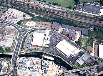
Aerial view over the Kennet in Reading. To the bottom of the picture is an office block that replaced the old biscuit factory. To the top of the picture is a retail park on former railway land.The main town on the Kennet is Reading. This picture is looking north, showing the canalised lower Kennet in the foreground are the strip of buildings that are built on the river terrace between the Kennet and the Thames. The railway marks the northern edge of the terrace. The floodplain of the Thames is the grassed area in the background behind the railway. The confluence of the rivers is just to the right of the picture. The famous biscuit factory, Huntley and Palmers, used to occupy the Kennet-side site in the foreground, now occupied by a white-colored office block.
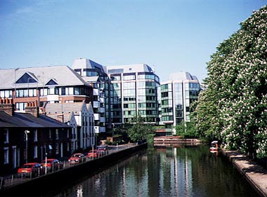
The canal diversion that took the Kennet past the Huntley and Palmer's site. The abbey and prison are on the right in this picture, which looks west towards the town center.The Kennet diversion to the old Huntley and Palmer's factory is now one of the places where new offices have been built. The line of this diversion was the bed of the old Holy Brook, a tiny tributary of the Kennet and once the mill stream for Reading Abbey. The remains of the mill are behind the green office block; the remains of the abbey are to the right of the picture. This view looks west. |