|
North Yorkshire Esk
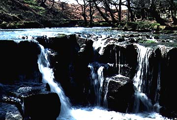
The upper Esk flows in gorges created towardS the end of the Ice Age. The river now tumbles over steps in the gorges where hard bands of sandstone stop erosion. This is Thomasson Foss near Goathland.The River Esk drains the northern part of the North York Moors and reaches the North Sea at Whitby. This short river is geographically one of the most interesting in Britain The main river flows eastward, following a straight, but steep path to the North Sea. It cuts into near horizontal beds of sandstone, shale and limestone. These changes in rock type give the main valley sides of the Esk a notably stepped appearance. They also control where many springs occur and so also influence the location of hillside villages. The Esk Valley has some of the steepest roads in Britain as the roads run down over the bands of hard rock that resist erosion. Even the main roads into the Esk valley are very steep, including the Blue Bank on the main route to Whitby. Although the main valley is generally broad and wide, the headwaters contain a number of quite mysterious features. Among the most mysterious are the gorges that occur in two of the southern headwaters. These gorges provide some of the most spectacular riverside walks in the North York Moors National Park. The gorges are cut in beds of tough sandstone. Water cascades over river-bed waterfalls, like Thomasson Foss. However, these falls are not the work of the present river, but of a former river Esk that once flowed as a raging torrent under a great ice sheet that covered this area during the Ice Age. This ancient river was carrying the water melting from the ice sheets. The sheer force of the water, combined with pebbles, sand and other materials scoured from the landscape by the ice, made it an exceptionally powerful and erosive underground river which simply ground out trenches in the rock over which it flowed. Today the tiny hamlet of Beck Hole near Goathland lies at the junction of two such gorges. A little up river along the Murk Esk lies the tourist attraction called Mallayan Spout. This tiny waterfall plunges down into one of the ice-cut gorges, without hardly changing the gorge sides at all. This shows how puny the present river is compared with the ancient Ice Age giant that created the valley. Just as strange as the valley bottom gorges are the great hillside trenches that criss-cross the moors and connect to the neighbouring drainage basins. Newtondale is the most spectacular of these. Again, they were formed during the late Ice Age, this time at the edge of the ice sheet rather than under it. Each great channel marks the line of the ice and the river that ran beside its margin. Newtondale shows a river that once ran south from the Esk to the south when the end of the valley was blocked by ice and the Esk valley was a giant lake. But, as soon as ice retreated from the mouth of the Esk, the river flowed back to the North Sea, abandoning the trench and leaving it much as we see it today. The modern Esk makes its way east through Sleights to Whitby, creating a spectacular natural harbour in a coast notable for its ferocious storms and its lack of harbours. For this reason Whitby grew to be a famous town for fishing and whaling ships. Captain Cook, born a few miles north of Whitby in the small village of Staithes, sailed from Whitby on his great world voyages. The Esk valley provides one of the easiest travelling routes through the moors. In the 19th century many railroads chose to follow the Esk, using its gorges and trenches to cross the high moors. Once used to carry freight, many railroads have been abandoned, but some remain as tourist attractions. The Grosmont to Pickering North York Moors Railway follows Newtondale and the Esk gorges to give tourists one of the most spectacular train rides in the country.
Field Trip suggestions on the EskOne of the best ways to see the nature of a river on the moors is to begin on the high moors below the Roman Road south of Goathland. Here, close to the Youth Hostel and Hunt House, the meandering of a small stream can be examined. There is a short stretch where there is no public access to the river bank, but then a pathway follows the river down to Beck Hole. The section from the road to Mallayan Spout takes in some impressive gorge scenery and gives the chance to examine the nature of the sandstone and how resistant beds create waterfalls. Remember that the gorge was not eroded by the present river, however. Also note that the large boulders in the river bed are hardly being eroded by the river, so it is a good opportunity to examine how effective a river might be and not to take for granted the fact that all materials close to rivers are produced by river action. In this stretch, too, look for signs that the trees have been slipping on the steep slopes. The path crosses many systems of tree roots and most trunks have a distinctive curved shape as they try to grow up before toppling over. Also along this stretch are many seepages of water from the sandstone. The boggy patches are hard to miss along the route and could provide the focus for discussing how rivers are fed by groundwater and also by water flowing from hillsides. Mallayan Spout is an interesting example of a waterfall (that only flows when there has recently been rain). This can be examined for the special types of plants as well as to see if the waterfall shows any signs of erosive power. Again, because it is so small, the waterfall has had little impact on the gorge wall. Down river of Mallayan Spout the valley widens and provides a good opportunity for looking at any evidence of landslides. The hamlet of Beck Hole has many historical connections (it was once the site of iron mining), and it is well worth examining for the way the North York Moors Railway uses the eastern river gorge as a way across the moors. From Beck Hole to Grosmont the river changes character again, for the wide valley of the main Esk is reached and it is an opportunity to investigate river meanders, although in many places public access to the river bank is limited. Look at Grosmont to see how this once iron mining and processing settlement (and the terminus of the North York Moors Railway) has developed with relation to the river and the need to keep clear of river flooding.
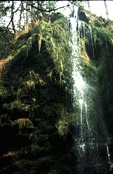
The Mallayan Spout is a picturesque waterfall that plunges from the village of Goathland into the gorge of the Murk Esk river.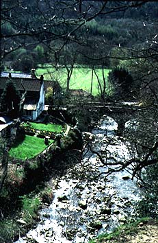
Two main tributaries of the Esk meet at the tiny hamlet of Beck Hole. Beck Hole represents a place where a bridge was thrown over one of the rivers. It is also close to a former inclined railway used to haul iron ore out of the valley bottom. Today the hamlet is a center for walkers on the North York Moors.
The Larpool area, or inner harbour, of Whitby, looking out to sea.
The swing bridge at Whitby is the lowest bridging point of the Yorkshire Esk. The picture is taken from the sandstone cliff called the Khyber Pass looking inland.
Places on the Esk
Whitby
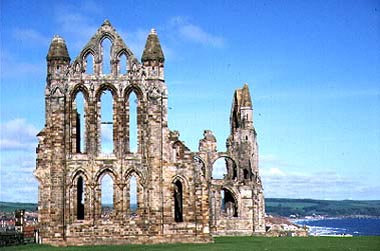
Whitby AbbeyWhitby is a seaside town in northeastern England. It is about 60 kilometres (40 miles) west of Leeds and about the same south east of Teesside. The town population is about 70,000. Whitby means The place by the light (white) cliffs. This is a Viking word, for Whitby was founded by the Vikings.
Whitby lies on the coast in an area where the high North York Moors reach out to the sea. There are few sheltered harbours along the North Yorkshire coast, and so the place where the River Esk cuts a natural harbour has been a very prized location for many centuries. But it is not an easy place to live in because there is not much room beside the river. This is why the oldest and largest building in Whitby, the abbey, was built on the top of the East Cliff. The ruins of Whitby Abbey are still a prominent landmark, both for people out to sea and for those on the moors inland. Although the Abbey was built for solitude in about the 6th century, people cannot live isolated from the world and so a village grew up on the east bank of the river, below the Abbey, also most sheltered from the northeasterly winter storms. This is where Old Whitby was founded, where the village grew into a small town and where the marketplace it situated. Old Whitby was a busy fishing port. For centuries Whitby was a sheltered harbour close to important North Sea fishing grounds. Old Whitby was funnel-shaped, being narrowest at the harbour and spreading out a little as there was more room inland. Just inland was where ships were built. When Whitby became a seaside resort, space had to be found for many buildings and this is when building spread across the West Cliff, giving good views over the harbour and out to sea.
Whitby people have always looked to the sea for their livelihood. Over the centuries, Whitby became one of the foremost fishing and whaling ports in Britain. Captain James Cook, the famous explorer, was born and raised in the Whitby area and learned much of his seafaring skills there. One of the ships James Cook used in his world-wide voyages was a converted collier. Fishing attracted more industries. For example, boats were built in the sheltered river mouth. Whitby ships helped to carry coals from Newcastle to London for several centuries. As a result of all of these activities, Whitby became a small, but prosperous town. During the last century the railway reached Whitby and allowed people to visit Whitby for their holidays.
Pictures
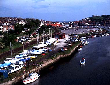
A view across the inner harbour looking out to sea. The abbey is on the right.
A century ago the many docks along the waterfront would have been filled with sailing ships loading and unloading. This picture shows part of the oldest surviving dock area in the port. It gives you some idea of what the old port was like.
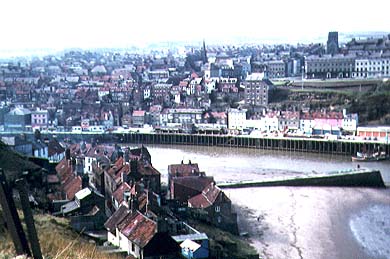
This is a view over the old town across to the Victorian expansion on the West Cliff
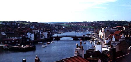
Whitby swing bridge taken from above the road cutting called the Khyber Pass on the West Cliff.
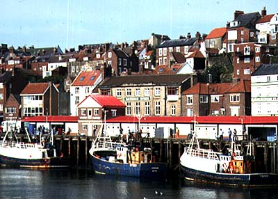
This is a view of the fishing quay at the foot of the West Cliff. |