|
River Dee/Dyfrydwy, Welsh BordersTributaries include the Conway/Conwy

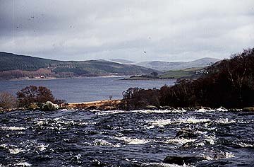
The Dee at Bala Lake.The Afon Dyfrdwy (which is called the River Dee in England) has its headwaters in the Cambrian mountains just to the east of Bala Lake. From this lake it flows eastward through Llangollen then south east to Chirk before making a sharp turn north and flowing to the east of Wrexham (Wrecsam) to reach the Irish Sea just north of Chester. In geological terms the Dee is an extremely interesting river because its eastward course in Wales takes it across many kinds of hard and soft rocks. This is why, as it passes over hard rocks, its course becomes deep and narrow and even waterfalls occur, whereas as it crosses softer rocks the valley widens out. No river could cut through such varied rocks in this way unless it had once flowed over a much more uniform sheet of rock that sloped east. In fact it is believed that the Dee once linked eastward to the River Trent and so flowed out to the North Sea! How did everything change? The answer is that, over time, the rocks that once sloped east have been eroded away. As the rocks were stripped away, so other rocks were revealed below whose 'grain' was from north to south. So as the Dee cut down further, it had to adjust to crossing a wide variety of rocks as described above. Geographers call this superimposed drainage. It is very difficult for rivers to flow across the grain of the country because it is very slow cutting through the hard rocks. This gives other rivers a chance to cut down even faster and alter the course of the Dee. If you look at the Afon Conwy on a map, you will see that it is a very short river, flowing north through Betws-y-Coed to the sea at Conwy. If you study the headwaters into Snowdonia National Park, you will see a very curious pattern. All the headwaters flow east before turning to flow north. In fact all these headwaters once belonged to the Dee, but because the Conwy has a short route over a band of soft rocks to the sea, it has been able to lower its valley and extend its path farther and farther south until it has cut right through the headwaters of the Dee and captured them. This is one of the best examples of a geographical feature, called river capture, anywhere in Britain. But there is even more capturing to come, for the lower Dee is, like the Conwy, a short river flowing north. In the past it, too, cut a path south to cut into the Dee at a time when the Dee once connected east to the Trent. This capture accounts for the sudden northward bend in the present River Dee. In fact, the Dee abounds with interesting physical geography features. For example, the estuary of the Dee is, like the Mersey, unusually wide. The river did not cut this. It is a feature left over from when, during the Ice Age, the ice pushed ashore, then retreated, leaving more material on the promontory of the Wirral, than elsewhere.
Places on the Dee
ChesterChester lies on high ground in a meander of the River Dee. The city is still enclosed by its old walls which date from the 14th century. These were not the first walls, however, for they merely replaced the Norman ones, which had replaced the Roman walls. Traditionally the River Dee was crossed by two bridges at Chester - one with seven arches and the other a single span. Protected inside the meander and the walls lies the old city. The four main streets meet at the market cross. Here lie some of the oldest and most unique shops in Britain. Known as the Rows, the shops contain galleries which occupy the front of the first floor of the buildings and are reached by stairs from the street. Many are black and white timber buildings dating from the 16th and 17th centuries. The city has a cathedral, a barracks and a castle, all again contained within the meander. The Dee used to be the port for the city, but over the centuries it became silted up and so reduced the shipping trade. No ships reach modern Chester. Chester was founded by the Romans and called Deva (the camp on the Dee). It was they who chose the defensive site in the meander because they needed a place from which to attack the Welsh. They used the river as a harbour. This is the Rodee, now the site of the racecourse. During the Middle Ages, the port was vital to the trade of Chester. It imported hides, linen from Ireland, wine from France and fruits and spices from Spain. It exported cheese, salt and candles.
Dee: Yorkshire DalesThe Yorkshire Dee flows west through the Yorkshire Dales National Park. Its source is near Wold Fell, from where it flows through Dent Dale to join the River Rawthey near Sedburgh. The fells (hills) on either side of the Dee are made up of layers of rocks of varying hardness. The top layer is hard Millstone Grit. This forms the tableland top to Whernside, the highest fell on the southern side of Dent Dale. Below this tough cap rock are thin layers of shale, sandstone and limestone called the Yoredale Beds, and below these again is massive gray mountain limestone. This sequence of rocks is unique to the High Pennines and gives the Dales their dramatically stepped valley sides. The springs that begin on the Millstone Grit and the Yoredale Beds often disappear down gaps that have been dissolved in the limestone. These gaps are called swallow holes. The water then follows an underground route where the limestone has been dissolved away underground, only to reappear lower down the valley side. The river can flow over the limestone if it is full of water. The top of the filled part of the limestone is called the water table. For much of its course, the River Dee flows directly on mountain limestone that is filled with water. Here the acid waters seeping from the peaty fell bogs have dissolved the limestone, opening out the cracks and leaving a rocky surface. Pebbles carried at times of flood have also drilled potholes in the limestone surface. Also, in places, the river has cut through some of the bands of limestone, giving small waterfalls along its course. These three features - etched bed, potholes and waterfalls - make the upper Dee one of the prettiest rivers in the Pennines.

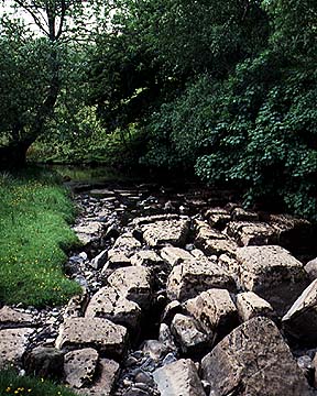
The limestone blocks show clearly in the Dee near Dent. See how they have been etched by the acid waters flowing off the moorsAs the river flows further down the dale, it flows no longer on hard rock, but on deposits in part left from the Ice Age, so that you can no longer see a rocky bed. Furthermore, the river begins to meander and a flood plain forms, making flat lands that were traditionally used as water meadows.
Places on the Dentdale DeeThe only settlement on the Dee is Dent, a historic and well preserved mountain village whose thick stone-built houses and narrow cobbled streets attract many tourists. It also has a memorial in granite to geologist Adam Sedgwick.
|