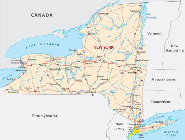
The landscape of New York was formed by the movement of glaciers thousands of years ago. The glaciers left nine different geographic regions in New York, each with its own types of landforms. To the east of the Hudson River lies the New England Upland, which extends eastward into Massachusetts and Connecticut and southward across the lower Hudson valley into Pennsylvania. The Adirondack Highlands in the northeast covers around one-quarter of the state. It has the highest and most rugged mountains in the state, including Mt. March (5,344 feet/1,629 meters), and Algonquin Peak (5,114 feet/1,559 meters). The Appalachian Highlands make up around one-half of the state, and extend from the Hudson River Valley to the basin of Lake Erie. This region includes the Catskill Mountains, Finger Lakes, Delaware Basin, and Kittatinny Mountain Ridge (or Shawangunk Mountains).
Between the two large upland regions, and along the state’s northern and eastern borders, there is a network of lowlands, including the Great Lakes Plain; the Hudson-Mohawk Lowland, Lake Champlain, and the St. Lawrence Lowlands. Two small regions complete the geographic picture in southeastern New York. The Atlantic Coastal Plain, which extends from Massachusetts to Florida, includes Long Island and Staten Island. A small finger of the eastern Piedmont region also juts up from New Jersey for some distance along the west bank of the Hudson.
New York contains around 8,000 lakes. The largest lake completely within the state is Oneida, which is about 22 miles (35 km) long. Many smaller lakes are found in the Adirondacks and in the Finger Lakes region. There are 11 Finger Lakes (including Owasco, Cayuga, Seneca, Keuka, Canadaigua, and Skaneateles), named ‘finger’ because they are long and narrow. Three of the Great Lakes—Erie, Ontario, and Champlain—make up part of the state’s borders.
New York’s longest river is the Hudson, which extends for 306 miles (492 km) from the Adirondacks to New York Bay. The Mohawk River flows into the Hudson north of Albany. The major rivers of central and western New York State—the Black, Genesee, and Oswego—all flow into Lake Ontario. The Delaware, Susquehanna, and Alleghany rivers drain the southern and western portions of the state and provide a large part of New York City’s water supply. The East River connects Long Island Sound with New York Bay and separates Long Island and Manhattan. Other major rivers include the St. Lawrence in the north, the Poultney in the east, and the Niagara in the west. The Niagara Falls (which is shared with Canada) lies along the Niagara River. More than 1,585,000 gallons (60,000 hectoliters) of water flows over the falls each second.
Based on its latitude, the early Dutch settlers expected New York to have a Mediterranean climate, and were bewildered at its snowy, freezing winter weather. In fact, although New York is in the humid continental zone, there is a lot of variation in climate from region to region. The three main climate regions are the southeastern lowlands, which have the warmest temperatures; the uplands of the Catskills and Adirondacks, where winters are cold and summers cool; and the snow belt along the Great Lakes Plain, one of the snowiest areas of the US.
Average July temperatures range from 77°F (25°C) in New York City to 64°F (18°C) at Indian Lake in the Adirondacks; averages in January range from 33°F (0.5°C) on Long Island to 14°F (-10°C) at Stillwater Reservoir in the Adirondacks. Rainfall ranges from 32 to 45in (810 to 1,140mm) a year, with the Catskills receiving the greatest amount, and the Erie-Ontario Lowlands receiving the least. The area around Syracuse receives an average of about 115in [2,900mm] of snow each year.
The record low temperature for the state is -52°F (-47°C), recorded at Stillwater Reservoir in the Adirondacks on 9 February 1934 and at Old Forge on 18 February 1979; the record high is 108°F (42°C), recorded at Troy on 22 July 1926. Atlantic hurricanes and tropical storms sometimes cause heavy damage to Long Island.