|

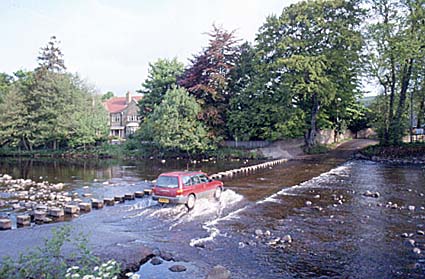
The ford over the Wear at Stanhope, Weardale.The River Wear has its source high on the sandstone Pennine Hills at the western end of Weardale. The eastern slopes of the Pennines are made of vast sheets of beds of sandstone with some limestones and clayey rocks called shales. But it is the sandstones that dominate, and they help give the acid soils that form over great areas of the moors. The moors are the permanent sponge that feeds the headwaters of the Wear, just as they do its neighbour, the Tyne to the north. Here the landscape of open moorlands has been only slightly cut into the Wear and the valley is wide and open. However, set within these wide valleys are rivers and tributaries that run often in deep narrow gorges, sometimes spilling over ledges of hard rock to form small waterfalls. But wild though this landscape is, the demand for water from the towns and industries of the Durham coalfield to the east has caused the construction of dams and the formation of the Burnhope reservoir on the upper Wear, just as elsewhere, so that the river flows in a more controlled fashion than in the past. The main road over the Pennines to Alston and then Carlisle makes use of the Wear valley to get at least some shelter on its way up onto the moors. But this, the main road, simply follows an ancient routeway that has been used for many centuries by drovers bringing their sheep down to market and by miners who found riches high in the valley. Stanhope is the old market town on the upper Wear. The old ford still exists, together with a road bridge some distance upriver of the ford. The Wear flows off the moors at Wolsingham, once the home of a thriving, if remote, iron works. Wolsingham marks the edge of the Pennine moors and the start of the landscape of the Durham coalfield. Here the landscape changes and the Wear begins to meander dramatically, passing through Bishop Auckland where it changes direction and flows north east to Durham. Durham City is sited in one of the most spectacular oxbows in Britain (see places below). From Durham the Wear flows almost directly north to Chester-le-Street and then north east again to reach the sea at the port city of Sunderland. This curious route has come about because of a band of hard limestone that runs north south across Durham. The Wear runs parallel to this rock for it cannot cut through it until just south of Washington.
Industry and the WearLead was an important mineral in this high Pennine area, and Killhope Wheel, at the head of the valley, tries to reconstruct for visitors some of the character of this past mining time. There is still a giant waterwheel on the site, showing that water played an important part in the lives of the miners in crushing the ore. The Nenthead Mines Heritage center is near Killhope. This was the largest lead mining and smelting site in the North Pennines To the east of the Pennines, the Wear flows through one of the most important areas of coal in Britain. Stretching away to the east and under the North Sea lie vast reserves of coal. They come to, or are close to, the surface as they reach the Pennines, and it was here that many villages grew up as homes to the Durham miners. These were the coals that supplied the needs of the hearths of towns and cities as far away as London since Roman times. A reconstruction of the life and times of the Wearside miners is operated at the North England Open Air Museum at Beamish. The most important section of the industrial Wear was the estuary, dominated by the city of Sunderland. Here, in a coast that has few natural harbours, the Wear estuary provided a good opportunity for coastal colliers to load with coal from the coalfield.
Places on the Wear
Durham

Durham
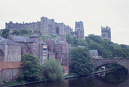
The ancient cathedral city of Durham occupies one of the most spectacular sites in Britain. The River Wear cuts a dramatic oxbow through hard sandstone rocks, so that, by simply defending the narrow neck of land, the city itself is almost impregnable. To protect northern England against invasions by the Scots, one of the most imposing of Norman castles was constructed, together with one of the most important of British cathedrals (founded in 1093). The site had already become a place of pilgrimage after the bones of St Cuthbert were interred at Durham in the 9th century and those of the Venerable Bede in the 11th century. As the home of important religious relics, and as a strategic site near the Scottish border on an impregnable river-side site, the scene was set for Durham to become the stronghold of the Prince-Bishops, some of the most powerful medieval rulers in the country. The medieval buildings dominate the inside of the oxbow, leaving little room for the growth of the city. As a result, the majority of the city has been built across the river, with many bridges connecting old and new cities. Despite its small size (population about 40,000), the historic importance of Durham has remained. For many centuries the prince-bishops of Durham represented the king in the north of England. And it was the last of these bishops who founded Durham University in 1836, setting it up in the castle and many neighbouring buildings. Durham and the Wear are among the most visited tourist sites in England.
Bishop AucklandThis is a small market town whose origins are connected to the Bishop of Durham's favourite country residence, Auckland Castle. It was converted into a castle in about 1300 by Bishop Bek. The Castle is surrounded by a park of 300ha.
SunderlandThe history of Sunderland begins in 674 when Benedict Biscop was granted land on the banks of the River Wear to establish a monastery. It was here, in the 11th century, that the Dark Ages historian, the Venerable Bede was a scholar. This area later became known as Monkwearmouth. The monastery was extended on land to the south of the Wear. This 'separate land beyond the river' or 'sundered land' gave its name to the city of Sunderland. The land eventually became part of the estates of the Bishop of Durham. The first coal was brought to the port of Sunderland from the Durham coalfield in the 14th century and, to transport it, ships were built. Beside shipbuilding and transporting coal, Sunderland was also a fishing center. Sunderland expanded by making salt, heating up the seawater using Durham coal. A new quay was soon needed to export salt and coal. Soon coal mines were being opened close to the coast, thus expanding Sunderland's role as an important coal port. In 1796 an iron bridge was built close to the mouth of the Wear to connect the settlements that were fast growing up on both banks. By the 1830's production of ships in Sunderland was greater than any other British town and in the nineteenth century it became the world's largest shipbuilding town. The railway era made the port even more important, but the depression of the 1920s dealt a fatal blow to the shipbuilding industry of Sunderland and shipbuilding virtually stopped. The industrial importance of Sunderland at the mouth of the Wear is testified by the fact that it was one of the most heavily bombed places in the Second World War. This was because the war revived the shipbuilding industry, due to the need for new ships to replace those sunk on the oceans. After the war the shipbuilding industry again declined and shipbuilding finished completely in the 1980s, followed by the end of coal production in the 1990s. As a result, Sunderland has had to look for a new range of industries, and for the first time they are not related to the advantages of the river.

Barnard Castle |