The Hoe marks the end of the Tamar estuary, separating the Tamar from Sutton harbour.Tributaries include: River Tavy The Tamar, whose mouth is on the south Cornwall/Devon coast, has its headwaters close to the North Devon coast. Thus, like many of the largest rivers in South West England, the Tamar flows almost across the whole breadth of the peninsular. This unusual pattern occurs because the land on which the Tamar once flowed, sloped toward the south. Although this south-sloping land surface has now disappeared because of erosion, its former presence is picked out by the rivers. The Tamar has twin sources, the Deer and the Claw. They begin close to Holsworthy in Northwest Devon. The two headwaters combine to make the Tamar at North Tamerton. For much of the rest of its route, the Tamar marks the boundary between the counties of Cornwall and Devon. The Tamar Lakes near Broadworthy in North Devon are the two reservoirs in the upper Tamar Valley. The oldest, built in 1820, is the Lower Lake. It was built to feed water to the Bude Canal. The Upper Lake was formed in 1975 to help to provide a reliable water supply to an area where there is little natural storage.
River LydThe Tamar flows to the west of Dartmoor, gathering waters from, among others, the River Lyd. The middle Lyd is famous for its spectacular gorge with potholes and waterfalls. This is a classic example of a process called river capture. The River Lyd has actually cut into and diverted the headwaters of another Tamar tributary, the River Tavy. This has happened because the Lyd flows over much softer rocks than the Tavy and so it has been able to cut down faster. Lydford Gorge (owned by the National Trust and a favourite location for field trips) marks the point of capture. South of Launceston the rocks to east and west were once rich with tin, lead, silver, zinc and other important metals. These gave rise to a spectacularly important mining industry in the 19th century. Naturally, people were anxious to get the metal to market as cheaply as they could and water transport was the obvious answer. However, the Tamar's upper course is too shallow and has too many meanders to allow a port to be founded high up the river. However, below Gunnislake, the lowest bridging point and tidal limit of the river, things change. Down river of Gunnislake the port of Morwellham Quay and Cotehele Quay were founded specifically to carry the metal ores to markets elsewhere in the UK and overseas, and to import coal and lime for ore processing. Both quays are now open air museums, illustrating the time when sailing barges carried ore from these once famous and thriving river ports. The main tributary of the Tamar is the Tavy. The Tavy drains the western flanks of Dartmoor. The most important river town on the Tavy is Tavistock. The Tavy and the Tamar meet at the Tamar estuary, which is known as Plymouth Sound. This spectacular estuary is a natural harbour and it is here that the city of Plymouth developed. The Tamar estuary may be a splendid natural harbour, but this has also made it a major obstacle to communication between Devon and Cornwall. In the 1840s, the Great Western Railway Company began their London to Penzance route. The Tamar presented such a formidable barrier that it took until 1859 for a bridge to be constructed. Now the Brunel Bridge is one of the most famous of all 19th century railway bridges. In 1961 a road bridge was built beside it, although a single road link is not enough to prevent frequent congestion at the river crossing.
Places on the Tamar
LauncestonLaunceston is the largest town on the upper Tamar and the ancient capital of Cornwall. It lies above the River Kensey close to its confluence with the Tamar. Launceston has been a route center of the upper river since ancient times. The oldest crossing point was little more than a series of stepping stones, because the Kensey is shallow. Next to the crossing a Priory was built. A Norman castle was built to protect the crossing and the east west route leading through the Kensey valley across the Tamar to the rest of England. The town grew up on the steep slope between the castle and the river. The Castle on its Norman mound still dominates the center of the town. Launceston was the only walled town in Cornwall and fragments of the walls still remain. However, the huddle of medieval streets are the best sign of the former walls. This traditional crossing was still used until the modern bypass was built. The Kensey valley still boasts a narrow gauge steam railway.
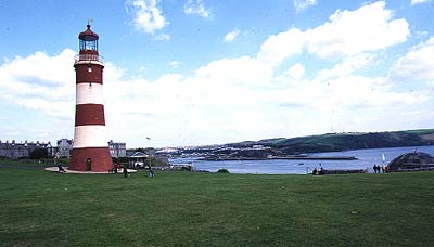
PlymouthWhere the modern city of Plymouth now stands was called Sudtone in the Domesday Book. The Tamar's superb sheltered natural harbour meant that by the 14th century it had already become an important naval port. It was from here that English troops left to fight in France. Plymouth, however, got its modern name after its site at the mouth of the small River Plym which flows into the Tamar estuary. And indeed, it was the more accessible small harbour at the mouth of the Plym (called Sutton Pool), rather than the Tamar, that developed as the merchant ship center and it is here that the quays can still be found. Plymouth first became famous in popular history when the English fleet under Sir Francis Drake sailed from Plymouth harbour to meet the Spanish Armada in July 1588. It was also the port from which many explorers left to discover the New World and even to sail around the world. It was from here that the Pilgrims (Pilgrim Fathers) sailed to North America in 1620. For centuries the Tamar harbour has been an important base for the Royal Navy and Plymouth's heritage is closely tied to the provisioning of the navy and the building and repairing of its vessels. The naval docks developed in the main Plymouth Sound at the town of Devonport. The first docks date back to 1690, and for many years Devonport was called Plymouth Dock.
TavistockIn 1281 Tavistock became a stannary town, meaning that it was licensed to weigh and stamp tin collected from the surrounding mining area. However, the center of Tavistock is not old, having been remodelled in neo-gothic design in the 19th century by the Duke of Bedford using wealth he obtained as owner of nearby copper mines.
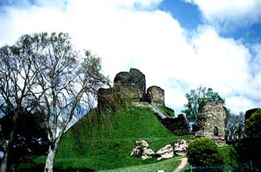
The castle of the Dukes of Cornwall at Launceston.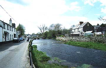
The River Kensey at Launceston. Here the river can be forded on foot. The Priory ruins are on the left (south) bank.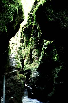
Lydford Gorge. This attractive site of river capture is on the River Lyd, a tributary of the Tamar that drains the flanks of Dartmoor.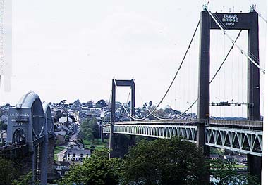
The main bridges over the Tamar between Plymouth and Saltash. The contrast between the famous railway bridge of 1859 and the road bridge of 1961 is easy to see.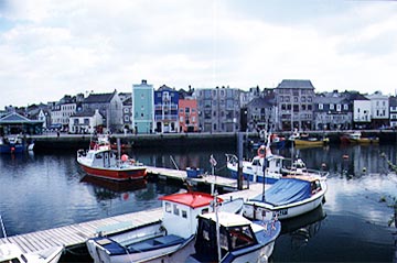
The old harbour at Plymouth was at Sutton. It has recently been redeveloped as a recreation and leisure center. |