|
The River Kent at KendalThe River Kent, the main river to flow south east from the Lake District, has its source to the south of the high ridge of the Lake District, called High Street. The headwaters carry water from the high fells (hills) down into a former glacial hollow (corrie) that is now partly filled with a lake - Kentmere Reservoir. From the lip of the corrie, the regulated Kent tumbles down into a glaciated (U-shaped) valley. The floor of the valley is too wide for the little River Kent to have formed itself, and the river moves aimlessly across its floor. At Green Quarter the valley narrows sharply, due to a band of harder rock across its path, only to widen again below the village of Kentmere. Another wide glacial valley follows and then again the valley narrows before meeting the Park Beck, a tributary from another corrie site. Beyond the hard rock band the valley is again wider, its straight sides and path telling that it, too, was largely shaped during the Ice Age. The Kent leaves the Lake District with its tough volcanic rocks at Staveley and flows out onto low undulating land. Here it is joined by the River Gowan. The lowland from Staveley to Kendal is largely a product of glacial scouring with a coating of glacial debris over it. As the Kent makes its way among the hummocks of this landscape it is joined by the River Sprint and then the River Mint. The Sprint has flowed through glacial Long Leddale, flowing south east and largely parallel to the Kent from its source on Harter Fell. Unlike the Kent valley, which widens and narrows several times, the Sprint valley is uniformly wide and has a more or less even gradient until it reaches the lowlands beyond the Lakelands. The River Mint's headwaters begin on the flanks of High House Fell and flow south east. This valley is much more like the Kent, narrowing where there are tough rock bands and widening where the rock beds are weaker. However, the valley shape was not formed by the Mint, but by a glacier that enlarged its valley during the Ice Age. The Mint turns south and then south west to reach the Kent. In doing so it follows an old glacially-scoured valley that cuts right through the ridge of high land that once joined the main Lakeland fells to Hay Fell to the east of Kendal.
South of Kendal the River Kent flows south to reach Morecambe Bay. The estuary is wide with great sandbanks, a sure sign that here, too, the valley has been overdeepened and widened by a former glacier. Thus, at the moment, the River Kent deposits its sediment in the former ice-shaped valley, rather than forming a delta.
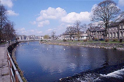
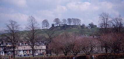
Places on the KentKendal Kendal commands one of the most important routes into the Lake District. A glacially scoured rocky crag overlooking the Kent was chosen as the site of the castle. But the Normans who established their castle were not the first people to defend this site. Just to the south, where the Kent makes a loop and so gives a good defensive site by the river, the Romans built a fort nearly a thousand years before the Normans.
Kendal and its castle from the bank of the River Kent. |