|
Exeter's medieval bridge over the River Exe.The River Exe is the longest river in Devon. It rises on the southern flank of Exmoor, in northern Devon, just 8 kilometres (5 miles) from the north coast. Like other rivers in the south west, because of the southerly tilt of the land, all rivers flowing south have much longer and less steep courses than those flowing north. South of Bampton, the Exe enters a long stretch where it flows in the bottom of a steep-sided and heavily wooded valley. This stretch is known as the 'Exe Valley' and is much visited by tourists because of its scenic beauty. The southern end of this reach ends at the town of Tiverton. To the south of Tiverton the valley widens to give a floodplain, although the valley sides remain steep and wooded. This floodplain is frequently flooded and remains pastureland. It is avoided by nearly all settlement. The valley widens at Exeter, close to the Exe estuary. The estuary is a ria, a partly drowned river valley, so common around the coasts of south west England.
Places on the Exe
TivertonTiverton (whose name means 'place by the double ford') is an ancient market town founded at a crossing point of the Exe at the southern end of the Exe Valley. Its ancient castle tells of the importance given to the crossing a thousand years ago. The town grew up around the crossing, and in the protection of the castle.
The Exe at Tiverton. The tall walls are for flood protection.
The old center climbs steeply from the side of the river, avoiding the flood plain entirely. The fact that people were prepared to build up a steep slope, with all the inconvenience that this entails, tells that the floodplain was not a safe place to be. However, as the town's industries expanded, it was decided to build on the floodplain and streets of workers' houses were laid out in this vulnerable location. To try to protect them from a river which is regularly liable to flood, a high flood protection wall has been built. The river now flows, rather unattractively, in this concrete 'corset'. Its most important industries became wool weaving and, later, lace making. John Heathcote established an important lace industry in 1816. A textile mill, built with its own diversion leat beside the river is still the biggest employer in the town. The Grand Western Canal, whose terminus at Tiverton is high above the town on the eastern flank of the valley, was constructed between 1810 and 1814. It was designed as part of a grand scheme to link the English and Bristol channels. Although this inter channel link was never completed, the canal provided a means of moving coal from Taunton and this allowed a lime industry to be developed using local limestone. The limestone was burnt in kilns close to the canal. The first kiln was built in 1829. Tiverton was an important cheap means of communication until the railway finally forced its closure in 1920. Today you can still see the 18 kilometres (13 miles) that remain of the Grand Western Canal because it forms a focus of a country park.
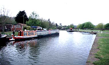
The Grand Western canal basin at Tiverton. Look at the background to see that the basin is on the side of the valley, not at the bottom of it.
BickleighThe Exe gathers most of its extra tributaries from the west, which is the north eastern flank of Dartmoor. It has almost no eastern tributaries because another river, the Culm, runs parallel to the Exe in its passage to the sea. One of these is the River Dart, whose waters flow in at Bickleigh. Here the narrow valley is guarded by Bickleigh Castle, founded in Norman times. The old stone bridges over the Exe and Dart still carry the main roads south from Tiverton.
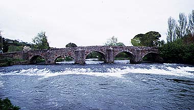
The stone bridge at Bickleigh still carries the main road down the valley. The bridge is only wide enough for a single vehicle and has a sharp bend at either end.
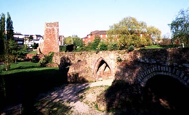
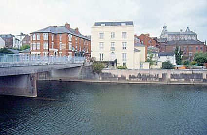
ExeterExeter (whose name means "The Roman station on the Exe") is by far the most important place on the Exe. It is the lowest bridging point and also the highest point of navigation of the river. It was this latter advantage that the Romans used when they founded Exeter by setting up their fort on the eastern bank of the river. As Exeter was also the most westerly outpost of the Roman Empire in England, the Romans also made use of another of a river's properties - that a river makes a good line of defense. The signal station of the Romans was built on a high bluff at the edge of the floodplain and overlooking the river. This good strategic point was to be immensely useful in later centuries when, as the main fortified town of western England, Exeter was often attacked by the Vikings. To ensure its protection the Normans reinforced the defense with a castle and high walls. A walled city was built in the shape of an oval, one of its shortest sides pointing toward the bridge over the river, the other end protected by the castle. In the center of the walled city lay the cathedral. The quays developed below the walled city on a relatively narrow strip of land. Just below Exeter, the Exe widens into the Exe estuary. To make it easier to move cargoes to and from the city, this lower part of the river has been extensively modified and dredged. An 8 kilometres (5 miles) canal links Exeter's quays with Topsham in the Exe estuary. The canal was a very early excavation, begun in 1564. The walls and the medieval bridge over the river are still largely intact, although the river has since been diverted so that the original bridge no longer has water flowing through it.
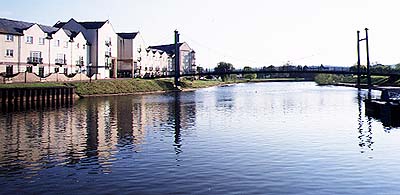
New housing development on the west bank of the Exe at Exeter. This housing lies on the floodplain.
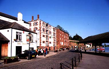
The medieval quay at Exeter. Although in use for general cargoes much later, the trade was superseded by the canal basin on the opposite bank.
ExmouthAt the southern tip of the estuary lies Exmouth, a town built as a resort. The estuary of the Exe is a fine example of a ria. |