|
SOMERSET AVON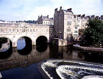
The Avon at BathThe Bristol Avon flows from the western part of Salisbury Plain then north through Frome and Trowbridge to Bradford on Avon, then west to Bath and finally Bristol. The Bristol Avon is one of the most curious of British rivers. Its headwaters lie on the eastern flanks of the Cotswold Hills. It begins flowing parallel to the headwaters of the Thames in an easterly direction. But at Malmesbury the Avon begins a huge U turn that will eventually bring it flowing west to the Bristol Channel around the southern edge of the Cotswold Hills. To see what happens you need to follow the course of the Avon from Malmesbury. In these headwater regions the Avon flows in a broad valley with gentle slopes. But at Chippenham the valley narrows. From here the river flows across the southern part of the Cotswolds and so it is forever cutting down, its valley narrow and its hillsides steep. From Bradford to Bath the Avon flows in the first of several gorges. When the Avon leaves the area of Bath it is in a steep-sided valley, but not a gorge. In part this is because it is cutting into relatively soft Cotswold limestone. Then it flows across the wide plain to Keynsham before diving into the Hanham Gorge. At this point the Avon cuts through sandstone, giving very steep wooded slopes. At Conham the river cuts an especially impressive entrenched meander. Below this gorge the river emerges again onto lowland before entering the most spectacular gorge of all, the Clifton Gorge, cut in steeply dipping rocks of hard 'mountain' limestone just above Bristol. Bristol marks the point of the last change, with the river arriving on the open coastal plain before entering the Bristol Channel at Avonmouth How could the Avon have made such a dramatic change in direction and also flowed across hills to cut these gorges? Part of the answer may be that the lower Avon always flowed west. This would give it a short steep course and so it would be able to cut into the land quickly. The upper Avon may have belonged to a tributary of the Thames. Flowing east on a gentle path it would not have been able to cut down as fast. Over time, therefore, the Lower Avon would cut down and back until it cut into the drainage basin of the upper Avon, causing it to change course. This process is known as river capture. Then the whole Bristol Channel has sunk (it is a rift valley) giving the rivers that flowed to it even more erosive power. But this is not the whole answer. To see what else has happened, it is interesting to notice that the Avon is not the only river that cuts spectacular gorges through hills. Just the other side of the Bristol Channel, the River Wye does the same as it flows through the edge of the Forest of Dean. Both rivers are in fact let down onto a landscape that rose up across their middle paths, forcing them to cut down into their beds. As time went by the rivers cut down and down, stripping away the topmost rocks and then flowing on whatever was beneath. This is the reason the Avon flows on two kinds of limestone and sandstone and also why it forms a number of gorges with lowlands in between.
Some places on the Bristol AvonThe deep valleys have had many effects on the way people used the Avon basin over the ages. For example, the By Brook is so deepened that the Romans avoided its valley and took the unusual course of rerouting their otherwise straight Fosse Way between Bath and Cirencester to the west of the valley and then around the valley head. The deep valleys have also hampered development (as in the case of Bath) while preserving some small rural villages from expanding with modern housing developments (as in the cases of Castle Combe and Lower Slaughter). All the towns and villages of the Avon - except for Bristol - share a common use of limestone for their houses and grand building alike, for the Avon flows dominantly through Cotswold limestone country. Furthermore, many towns and villages share the heritage of weaving from the days when wool was the chief commodity of the region and cloth meant wealth. Thus many places have spacious market streets and stately homes and even small cottages were so carefully built that they have stood the test of time. The water of the Avon is essentially hard water from the limestone rocks. This was important in the past because it is very suitable for the dyeing industry. This, rather than simply water power, was the main attraction of the river and its tributary streams for the gathering of many weavers in the tiny rural villages of the area.
FromeFrome straddles the River Frome, a tributary of the River Avon. It is one of the many towns of the chalk and limestone regions of Britain that flourished with the rise of the wool trade in the Middle Ages.
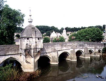
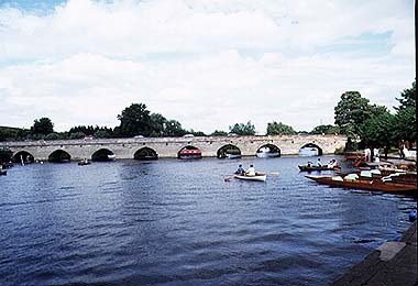
Bradford on AvonBradford is a Saxon town that still boasts a Saxon church (St Lawrence) sited, not where it could get flooded on the narrow flood plain, but on a flat ledge of land in the steeply-sloping hillside. The town became centerd on its Medieval stone bridge over the Avon. This bridge features a tiny chapel once used by pilgrims on their way to Glastonbury. Bradford prospered during the Middle Ages when the wool trade was at its height. The wool industry lasted longest in Bradford, and mills which lined the river banks have only recently closed.
BathBath is sited on a prominent meander in the River Avon, the city hemmed in by the steep sides of the Avon valley. Indeed, so steep is the Avon valley at this point that it is one of the most common places for landslides in Britain. The city may be molded by the shape of the river, but it was founded on the hot springs that bubble out of the ground and help feed the river. These mineral waters were long held to have curative powers. The Romans discovered the Iron Age people using the springs for ritual purposes, and they took over the theme, creating temples for their own gods. Later, when 'taking the waters' became a fashionable thing to do for health reasons, the wealthy flocked to Bath. Much of the center of the city dates from the time in the 18th century, when Bath was the most fashionable resort in Britain. Pultenay Bridge, built of local Bath limestone, was designed by Robert Adam in a classical style with 3 arches that exactly matches the Georgian character of the city.
Castle CombeThis tiny Cotswold village straddles the By Brook, a tributary of the Avon. Like so many Cotswold villages, its growth and prosperity were due to the wool industry of the Middle Ages. Castle Combe (combe means hollow in the hillside, usually containing a spring) was a center for cloth weaving and the old weavers' cottages still stand by the stream they once used. It was in Castle Combe that the two Blanket brothers invented a new kind of warm covering for beds. Their product was named after them - hence the name blanket still in use today.
MalmesburyThis formerly prosperous woollen cloth town on the northernmost part of the Avon occupied the angle of land between the Avon and its tributary, the Ingleburn. The result has been the need for six bridges in a place of modest size. It is also still possible to see the remains of the old riverside mills, even though they are now converted into apartments.
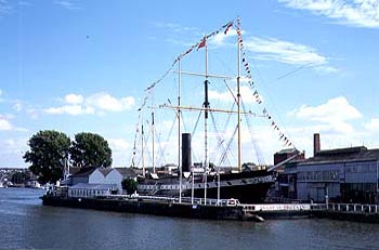
BristolBristol is one of the foremost river cities in Britain. Bristol was founded where the Avon and the Frome meet. This is a considerable distance inland, inland of the formidable Clifton Gorge, and the original site lacked a suitable place for a harbour. In an effort to bring trade to the town, the merchants of Bristol set about creating a harbour. A harbour was formed by 1247 by making the Frome flow further to the west. The original medieval stone bridge over the Avon marks the place where the rivers formerly joined. The town prospered with the new sea-going trade. Bristol benefited immensely from the opening up of the new North American colonies. The main imports were Jamaican sugar and molasses and West African cocoa. This was the origin of many famous industries in the city, including chocolate making. Bristol suffered in the long term because its port was inferior to that of Liverpool and because its location was not favourable to the places in northern England where the Industrial Revolution developed. Nevertheless, many more famous river-related events occurred. For example the first iron and steam ships, SS Great Britain and SS Great Western were launched here. When the railway allowed goods to be transported more easily, the city docks declined in favour of new docks at Avonmouth. Avonmouth Docks now include oil refineries as well as cargo handling.
AvonmouthAvonmouth is the place where the Avon enters the Severn estuary. The land nearby is flat and mainly mud. This has made an ideal site for the construction of docks and the development of industrial estates.
PICTURES OF THE SOMERSET AVON
The stone bridge at Bath is one of the few still surviving with houses and shops.
The stone bridge at Bradford contains a small building that may have been a chapel for pilgrims and later a local cell for those who misbehaved.
SS Great Britain is one of the ships that used to ply the Atlantic, using the harbour in the Avon as a trading port. The dockyard in which she was built now houses the ship and is a museum.
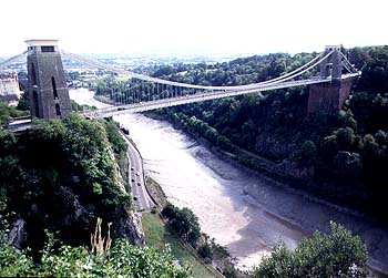
The Avon Gorge just above Bristol marks the upper limit of navigation of the Avon. It has been spanned by the Clifton Suspension Bridge, a famous bridge designed by I K Brunell in the middle of the 19th century.
HAMPSHIRE AVONThe Hampshire Avon flows south cutting through the Salisbury Plain on its way to the English Channel coast at Christchurch. The river flows through some of the oldest areas of habitation in Britain. Places such as Stonehenge lie close to the Avon valley. The source of the Avon is the chalk downlands of the east Salisbury plain. The Avon provided the only source of surface water in this otherwise dry chalk region and so its headwaters are lined with a string of small villages. Amesbury, near Stonehenge, is the first town on the river, begun as a crossing point of the river and still located at one of Britain's main arterial roads, the A303. Close to Amesbury an Iron Age fort was built some 2000 years ago, closing the narrow neck of an oxbow and using the river for defense. South of Amesbury the river flows in a steep-sided valley and so is avoided by major roads. But close to Salisbury the Avon is joined by its two major tributaries, the Wylye and the Nadder, and with this extra water, the river valley changes dramatically. Salisbury was actually not the first choice for a town in this area. Builders shied away from the wide and wet floodplain marshes of the valley floor and instead chose a hilltop site, now called Old Sarum This was easily defended. The Romans set up a nearby settlement and called it Sorviodunum (dunum means fort). Later, as the Saxons arrived, they changed the name to Saerobyrg, meaning armoured hill and then Sarisbury. When the Normans came they changed the r to an l because it was easier for them to pronounce and the name Salisbury came into existence. The name Sarum harks back to the old Saxon spelling. However, a site without a water supply is not able to grow, and so, in medieval times, the town was moved lock, stock, and cathedral, to its present river-side site, New Sarum, or Nova Salisbury, leaving the remains of Old Sarum on the hill. Salisbury Cathedral has the tallest spire in Britain, but the vast weight of stone on the soft floodplain muds has caused problems over the centuries and extensive supporting work has been needed to prevent the spire from collapsing. Below Salisbury, the Avon has a wide floodplain. A region of true water-meadows, it is criss-crossed with channels in an attempt to drain it. Mostly this has been to little avail and the floodplain is very prone to flood. Such a wide and marshy floodplain has proved difficult to cross. Few roads cross the floodplain until Ringwood, so that the Avon valley is surprisingly thinly populated. South of Ringwood the Avon is close to the sea. Here it meanders dramatically, producing a pattern of oxbows and cutoffs which again have kept people away. Not until Christchurch at the coast is the river crossed by another major road. Christchurch lies at the mouth of the Avon, and here a small harbour has been built, although the river itself is not navigable. An ancient castle marks the potential importance of the harbour as a way into southern England by ancient invaders and thus the need to defend it.
Pictures of the Hampshire Avon
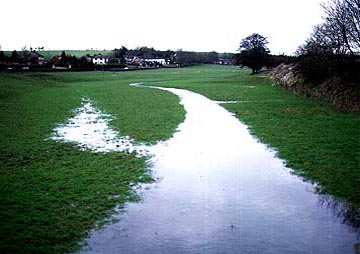
The source of the Avon changes with the height of the water table in the chalk. This picture shows the source in winter, but the lack of a channel tells you it is not this high for much of the year.
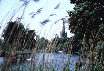
The tall spire of Salisbury cathedral seen from the floodplain just south of the city.
WARWICKSHIRE AVONTributaries include Swift Leam Itchen The Warwickshire Avon flows through the heart of the South Midlands of England. Its headwaters rise on a broad area of lowland to the east of Nuneaton, from where the Avon flows southwest to the east of Coventry, through Rugby, Royal Leamington Spa, past Warwick and Stratford to Evesham to join the Severn at Tewkesbury. This is a journey across the Midlands plains with their gently rolling hills formed on soft clay rocks, called marls, that produce deep red soils. But it is also a journey across a land that was once buried deeply under an ice sheet which left great thicknesses of bouldery clay (glacial till) behind after it melted away. This is the landscape that the Avon now flows over. By now you will have guessed that the Avon is forging a new course over land that was vastly altered by ice. But it is even stranger than that. Who would have guessed that flowing through a land steeped in history and traditions and with Shakespeare's Stratford at its heart, the Warwickshire Avon would be one of Britain's youngest rivers, not older than the Ice Age - a baby in the landscape? This is all the more surprising because you automatically feel that all rivers and valleys should be much the same age. So why is it that the Avon is as old as the nearby Trent, for example? To answer this we have to look back to the Ice Age and its effect on this part of England. In fact, in some ways the Avon is not as old as the Trent because, for much of its history, the Avon has flowed north east to join the Trent near Leicester. During the Ice Age the ice sheets pushed south and completely covered the Trent valley. Land to the south of their margin ran with torrents of melting water. Eventually the ice formed a giant dam that stopped the waters of the Avon flowing as they had for ages before, north eastward to the Trent. As a result a huge lake was formed whose southern edge was the Cotswold Hills. Higher and higher rose the lake and deeper and deeper became its waters until it covered all the present Avon valley from Leicester as far as Stratford. Then as the ice eventually melted away, the western part of the ice sheet melted first, so that the waters of the lake drained south west towards the Severn, while the land to the Trent was still under ice. As a result the river Avon changed direction, flowing for the first time in its existence to the south west and cutting itself off from the Trent forever.
Some places on the AvonRoyal Leamington Spa Rugby Warwick Stratford Evesham
Pictures of the Warwickshire Avon
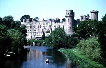
Warwick Castle guarding the route of the Avon.
The Avon at Stratford. The picture looks east with the town on the left (north bank). |