|
|
|
Length: 3200 kilometres (2000 miles); basin area: 850,000 square kilometres (330,000 square miles).
Tributaries include: Teslin, Pelly, Klondike, Porcupine, Takhini, White, and Tanana.
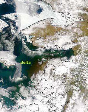
The Yukon delta. The delta and the Bering Sea are icebound for the majority of the year. This spring picture shows silt coming from the delta of the river.
There are no main cities on the Yukon. Fairbanks, Alaska is the largest in the basin; Whitehorse is the Yukon Territorial capital and largest city on the Canadian Yukon. Dawson, Fairbanks and Skagway became famous as gold rush towns. The Yukon, famous for the gold rush that occurred in the basin in the latter days of the 19th century, is both one of the most remote and unspoiled and also one of the major North American rivers. The river begins in the central Yukon Territory of Canada and then flows through central Alaska, finally reaching the Bering Sea, a part of the Pacific Ocean. The headwaters of the Yukon are a semicircle of high mountains. The lower part of the Yukon, by contrast, flows over a broad, gently sloping plateau. The Yukon has two main headwaters, the McNeil headwaters, that rises in the Pelly Mountains of south-central Yukon Territory (and called the Teslin River), and the Yukon itself, that begins in Atlin Lake. Below Atlin Lake lies the gorge of Miles Canyon and the former Whitehorse Rapids. A dam south of Whitehorse provides hydroelectric power, but it has flooded the rapids and the gorge is now part of a reservoir. The Yukon is frozen throughout the winter. The river ice only begins to melt in May. Snowmelt begins in much of the basin at the same time, and flooding is then possible. However, melting continues at higher and higher elevations, including the mountain glaciers, whose peak flow does not occur until the air temperature is at its warmest in July. As a result, the river flows strongly for several months. During this period the Yukon is often a raging torrent, and only afterwards does the flow abate, revealing the broad, shallow braided river bed. The gravel and stones of the bed are a relic of the glacial debris that once covered the area. Most precipitation in the area is of winter snow, for in the summer the basin is dry, with little rainfall. The Five Finger Rapids occur at Carnacks. Below this the Pelly River flows into the Yukon from the Mackenzie Mountains. Until the White River joins the Yukon, the waters are clear, but the White River drains major glaciers whose milky-colored and sediment-laden waters change the color of the combined river The Klondike River is a small tributary of the Yukon that enters the Yukon at Dawson. Prospectors found gold in the alluvial gravels of the river in the late 19th century. These are called placer deposits . As a result of the gold working, the whole river bed has been turned over and still shows the effects of this disturbance, the valley floor being hummocky with workings instead of flat as it naturally was. The broad lowlands around Dawson are followed by a narrow valley down river as it cuts through mountain ridges. Below this the confluence of the Yukon and the Porcupine River was the site for Fort Yukon, the first settlement in Alaska. Below Fort Yukon the river valley is broad again - an area called the flats. Then the river crosses another mountain ridge and flows deep in a gorge called the ramparts. The Tanana River is the main river to flow in from the south, and on this river is the town of Fairbanks. This, too is fed by glaciers and carries a large amount of sediment. Only one further tributary joins the Yukon below the Tanana, and this is the Koyukuk. Below this point the river follows a tortuous course trapped between mountain ranges until it finally reaches the Bering Sea at Norton Sound. Here the sediment is deposited in the form of a huge delta about 60 kilometres (40 miles) wide.
HistoryThe first Europeans to visit the area were Russian fur traders in the 1830s. The Hudson Bay Company began trading in the area in the 1840s. Paddle steamers began operating in the 1860s and were instrumental in getting prospectors part of the way on their journeys to the Klondike. They reached as far as Dawson City. The river boats continued after the end of gold rush days until, in the 1950s, roads were built connecting the towns. Few people now live in the Yukon Basin. The main population was at the time of the gold rush. Some mining continues, but distance from markets makes it difficult to mine economically. Most of the Yukon is tundra and supports no trees, so logging is not a major activity. Hydroelectric Power has not been much developed because there are few industries in the area to make use of it. Many people who live in the area are still of native American descent, and some still trap animals for fur, although most have migrated elsewhere in search of better jobs. The isolation of the area is increasingly attracting tourists and part of the Yukon is on the Alaskan Highway. |