|
In its upper reaches, the Snake's tributaries cut spectacular gorges into the western flanks of the Rocky Mountains.Length: 1600 kilometres (1000 miles); drainage basin: 280,000 square kilometres (109,000 square miles).
Tributaries include:
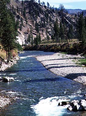
The Snake River (originally called the Lewis Fork of the Columbia River after Meriwether Lewis - see history below) is the major tributary of the Columbia River. It provides a fifth of the waters of the Columbia at their confluence near Pasco. The Snake drains a region of immense variety. In the south it is true desert with a rainfall of just 17 centimeters (7 inches). By contrast more than 150 centimeters (60 inches) of rain and snow fall on the forested mountain ranges. Widely regarded as one of the most beautiful rivers in the United States, the Snake River flows west and north, draining parts of the states of Wyoming, Idaho, Utah, Nevada, Oregon and Washington. The headwaters of the Snake are on the western slopes of the Continental Divide, in Yellowstone National Park. It begins its journey on the high pine-clad slopes of this volcanic district, then tumbles through gorges of the Rockies, through Jackson Lake in Grand Teton. Along the next section of its journey west, the Snake cuts into one of the largest basalt lava sheets the world has ever seen. Formed from vast outpourings of liquid lava, the basalt rocks often jut out in the river bank or the slopes of the valleys above. Here the river also flows over many rapids and waterfalls. Of special note are the American Falls and Twin Falls. Most spectacular of all, however, are the 65 m (260 feet) high Shoshone Falls near Twin Falls. Here the river falls over a horseshoe-shaped rim some 275 m (900 feet) long. The western route changes at the junction of the Boise River and the Snake swings northward on its way to the Columbia. From the eastern tributaries, including the Boise, Salmon and Clearwater, the Snake collects water from the Sawtooth and Bitteroot mountain ranges. Along this stretch the Snake forms the boundary between Idaho and Oregon. In eastern Idaho the river is also the source for the tributaries that sink underground in the lava fields and reappear as springs that cut deep sided canyons into the Snake valley. The northern part of this arid route ends spectacularly at Hells Canyon, whose depth of 2400 m (7900 feet) is even greater than the depth of the Grand Canyon on the Colorado. Hells Canyon is some 160 kilometres (100 miles) long and at its end the Snake flows into the Columbia at the town of Lewiston (named after Lewis, see below)
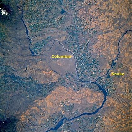
The confluence of the Snake with the Columbia.The Snake River is still rich in wildlife. The Snake River is also an important point of the migration routes for many waterfowl, and one and a half million ducks stop over each winter here. There are strenuous efforts made to conserve the natural beauty of the river despite the conflicting needs for water supply that has resulted in many dams and reservoirs along the river's route. One of the casualties of the dams on the river has been the removal of the habitat needed for salmon and sturgeon. This was once one of the prime salmon rivers of the country, but loss of half of the spawning grounds has made the salmon and sturgeon far less common than they once were. Now attempts are being made to recreate the habitat and allow the salmon to return once more. One of the most important of the many conservation areas that have been established on the river is the Birds of Prey National Area south of Boise. This area has the greatest density of many of the native birds of prey in all America. Snowmelt is an important contributor to the runoff of the river. In Spring each year there is the likelihood of floods, the ferocity of the floods depending on the depth of snow that has fallen during the previous winter and the speed at which it melts with the first warm winds of Spring. For much of the rest of the year the land around much of the Snake is parched. In attempts to conserve this water for the use of the towns and farms in the basin, the river has been extensively dammed, creating numerous reservoirs. The Snake river valley is also a very popular location for outdoor recreation, not just water-related sports but also hiking in the mountains and for hunting, fishing and wildlife watching.
HistoryThe earliest people to live by the Snake were the Native American tribes, but these peoples were nomadic and did not settle permanently by the river. When the river was explored by Europeans, they found rapids and deep canyons. They called it "The Accursed Mad River". Lewis and Clarke were the first people to write down details of the Snake River during their expedition of 1805. The Snake Basin formed part of the Oregon Trail bringing settlers from the east. Thus, during the 1840s there were skirmishes between the native Americans and the new settlers. In 1861 gold was discovered in the Snake Basin and this added large numbers of people to the basin. The increase in population caused an upsurge in the amount of food required and so farmers began to use the Snake waters to irrigate the farmlands and grow enough crops for the newcomers. Since then many reclamation projects have been undertaken. One of the earliest was the Boise Project of 1908. Today some 2.5 million hectares (6 million acres) of land are irrigated in the Snake River Basin. The need to get irrigation water onto the fields led to demand for more electric power. Thus dams were built on the Snake not just to provide a store of water for irrigation during the summer, but also to provide hydro-electric power. By 1906 dams at the American Falls, Minidoka, and Palisades were producing electric power. The largest of the many dams that followed were built in Hells Canyon. These are the Brownlee, Oxbow, and Hells Canyon dams. The era of dam-building is now at an end because of the pressure for conservation of what remains of this wild and beautiful region. Meanwhile, a ten-year project by the U.S. Army Corps of Engineers ended in 1975 with the creation of the 1100 kilometres (700 miles) Columbia-Snake Inland Waterway.
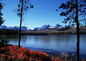
Numerous glacially eroded and moraine-dammed lakes like this one dot the high mountains of the Sawtooth National Recreation Area. |