|
Length: 2200 kilometres (1400 miles); drainage basin: 237,000 square kilometres (91,000 square miles). Tributaries include Pease, Wichita, Sulphur, and Ouachita rivers.

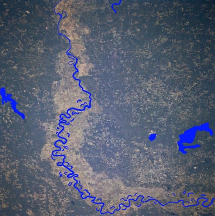
Red River Valley, Northwest Louisiana, U.S.A. This south-looking photograph shows the broad, largely cultivated floodplain of the Red River as it makes a 90-degree course change from east to south just east of Texarkana. Highly reflective sandbars, spaced randomly along the main channel of the river, allow it to be traced across the floodplain. Visible are large, dark Wright Patman Lake southwest of Texarkana and elongated Lake Erling in extreme southwestern Arkansas. Most of the landscape is gently rolling hills.The Red River, a tributary of the Mississippi, flows directly eastward though south western United States, its meandering course forming the boundary between the states of Oklahoma and Texas. It then flows into Louisiana and enters the Mississippi between Natchez and Baton Rouge. The Salt Fork and Dog Town Forks of the Red River rise in the Texas Panhandle near the New Mexico border. The Red River is noted both for its braided channel and for its meanders. The upper course is sandy and the river is wide, shallow and braided. In the middle course, beginning just above Lake Texoma, the river flows through gently rolling hills of red clay. This gives the river much red mud to carry and this is how the river got its name. While it is flowing in the clays, the bed in confined to a single, meandering channel. The meanders are very pronounced and there have been many meander loops cut off in the past, leading to a flood plain dotted with oxbow lakes. The Red River fluctuates greatly through the year, rising quickly after late spring and summer thunderstorms, and occupying a floodplain up to 30 kilometres (20 miles) wide. To try to stabilise this flow, the Denison Dam was constructed, above which Lake Texoma (600 square kilometres (225 square miles)) is impounded. The upper part of the river drains a semi-arid land and cuts through salt and gypsum beds. This makes the river water exceptionally salty and unsuitable either as a source of drinking or irrigation water. As the river moves toward the coastal plain, the rainfall becomes more reliable and the river fluctuates less markedly. The increased rainfall also results in the river increasing its total volume greatly. The lower part of the river is navigable to Shreveport |