|
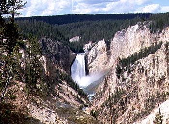
Yellowstone River, one of the headwaters of the Missouri.Location: 40N 95W (USA); length: 4300 kilometres (2700 miles); drainage basin: 1.4 million square kilometres (500,000 square miles). The Missouri is the largest tributary of the Mississippi and also, in its own right, the longest river in the United States. It contributes about a fifth of the waters of the Mississippi. The Missouri flows in a generally southeasterly route, from its headwaters in Glacier National Park, Montana, to its confluence with the Mississippi at St. Louis, Missouri. As with all of the rivers that flow eastward from the Rockies, the land they flow through is dry. Most of the water for the river is obtained from melting snows in late spring and summer rainstorms. For much of the year little further water is added as the river flows across the Great Plains. This is the reason why, while the drainage basin of the Missouri is so great compared with the Mississippi, it contributes relatively little to the total flow of the Mississippi. The main tributaries of the Missouri are the Yellowstone, the Platte and the Kansas, each draining the Front Ranges of the Rocky Mountains. For much of its route over the Great Plains, the Missouri flows over thick silt and sandy sediments in a wide, sometimes braided course. The high sediment load turns the color of the water brown, hence the nickname for the river: 'Big Muddy'.
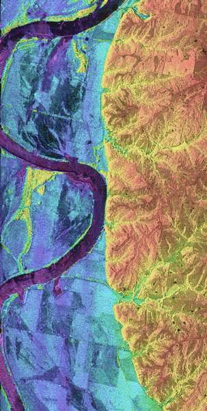
The meanders of the middle Missouri.The Missouri basin was one of the areas explored by Lewis and Clarke in the early 19th century. At this stage the main inhabitants of the basin were native Americans and a few fur traders. Later, steamboats were to bring commercial life to the river. The difficulty of making use of the river stems from its variable flow. It floods in late spring and then begins a long decline through the summer and winter. To try to make use of the water, a number of dams have been built (as part of the Missouri River Basin Project), so that the river is now more like a staircase of ponds. The water provides irrigation for cereal fields, hydroelectric power and flood control protection. Each of the lower dams is bypassed by locks so that barges can now reach Sioux City. Iowa. 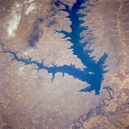
Fort Peck Reservoir, Montana, U.S.A. Fort Peck Dam, one of the world's largest earth-filled dams, and Fort Peck Reservoir are featured in this west-southwest-looking, low-oblique photograph. Fort Peck Dam was completed in 1940 as one in a series of dams built in the 1930s, 1940s, and 1950s along the upper watershed of the Missouri River. Besides providing flood control, hydroelectric power, irrigation water, and recreation facilities, the dam serves to impound water for later use from spring rains and snowmelt that swell the Missouri River. Fort Peck Reservoir is approximately 220 kilometres (135 miles) long and a maximum of 26 kilometres (16 miles) wide. |