|
Length: 1650 kilometres (1025 miles) from Great Slave Lake. From furthest headwater: 4240 kilometres (2640 miles); Basin area from Great Slave Lake: 1.8 million square kilometres (700,000 square miles).
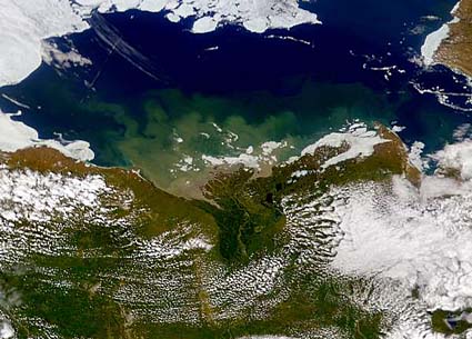
The Mackenzie delta in the Arctic Ocean.The Mackenzie is the second largest river in North America after the Mississippi. The full drainage basin covers an area about the same size as Mexico. It flows northwestward through Canada from the Great Slave Lake to the Beaufort Sea (part of the Arctic Ocean). For much of its length, the Mackenzie is a braided river, its pebbly bed containing innumerable shifting islands. Typically the river is shallow but wide. Even in meander sections it is up to 3 kilometres (2 miles) wide, and in extensively braided sections its width increases to 6 kilometres (4 miles). The river is generally wide, mostly from 1.5-3 kilometres (1-2 miles) across; in its island-dotted sections it is 5-7 kilometres (3-4 miles) wide. The headwaters, the Finlay River, rise to the west of the Rocky Mountains and drain the plains of northeastern British Columbia and northern Alberta. Major tributaries on this upper region include the Liard (about 274,000 square kilometres (107,000 square miles), Peace (300,000 square kilometres (116,800 square miles), and Athabasca (95,000 square kilometres (36,800 square miles) rivers. Glaciers form the source regions of several headwaters. More rivers drain from the Canadian Shield to the east. Many of these rivers drain into the Great Slave Lake (68,750 square kilometres (11,000 square miles), Great Bear Lake (31,000 square kilometres (12,100 square miles), and Lake Athabasca (7700 square kilometres (3000 square miles). The basin is inaccessible and frozen solid in winter. Forests cover the southern parts and tundra the north. Permafrost underlies extensive areas. The Mackenzie delta is noted for its ice mounds called pingos. The low population, harsh climate and inaccessibility combine to make much of the Mackenzie basin wilderness. The main settlements exploit the mineral resources of the area including oil (in the delta) and also the Athabasca tar sands on the Athabasca river north of Fort McMurray. The Peace River was the first to be harnessed for hydroelectric power, creating Williston Lake. Since then developments have taken place on the Snare and Taltson rivers. The Great Slave Lake lies at 156 m (512 feet) above sea level, but is up to 600 m (2000 feet) deep. Its great depth has been caused by glacial scouring during the last Ice Age. Its surface freezes in winter. The large volume of water in the lake means that it becomes ice free after the river, with ice flows remaining until June. The tributaries begin to thaw before the main river. This means that flooding over the Mackenzie occurs each year. The Mackenzie river itself begins to thaw in mid-May . During the break-up, huge ice dams can form, and these cause widespread flooding. By June all by the sea off the delta are free of ice. The outflow of the Great Slave Lake (the traditional source of the Mackenzie) is very wide and difficult to cross. However, it soon narrows from 10 kilometres (6 miles) to about 2 kilometres (1 mile) and here it is possible to cross the river. This strategic site was chosen for the siting of Fort Providence. The river is crossed by the Mackenzie Highway to Yellowknife at this point, although there is no bridge over the river and the highway is thus passable only when the river is frozen. No traffic can cross during the period of the thaw, and a ferry operates in the summer. The river widens again below Fort Providence to form Mills Lake. After Mills Lake the river narrows and flows through Green Island Rapids. The Mackenzie is a clear river because it drains from the Great Slave Lake. By contrast its first major tributary, the Laird, is sediment laden and muddy. The difference in density of the water keeps the rivers separate for 500 kilometres (300 miles), so that two rivers flow side by side in the same channel. In this, and lower reaches, the river has built high gravel levees, some 50 m (200 feet) high. The wide lowland beyond the river is underlain by permafrost and although it supports a few trees, it is, in the summer, mainly swamp. The special term muskeg is used for this permafrost, bog, lake environment. At Wrigley, two tributaries, the Redstone and the Keele rivers enter from the west. While flowing through the Mackenzie Mountains they have steep courses and flow in deep canyons, but once they enter the Mackenzie lowlands they become braided rivers. The peak flow of these rivers is in late June and corresponds with snowmelt. From this confluence the Mackenzie gains few tributaries as it passes through a rainshadow area of low rainfall. However, at Fort Norman the Great Bear River, the outlet from the Great Bear Lake, flows into the Mackenzie. As before, the clear waters from the Bear lake remain separate from the now sediment laden waters of the main river for some distance. Below the confluence of the Mountain River lie the Sans Sault Rapids, where the river drops about 6 m (20 feet). Near Fort Good Hope, the Mackenzie enters the Arctic. The Mackenzie then flows through further limestone gorges with 40 m (130 feet) sides called The Ramparts. The Mackenzie has a huge delta (see picture at top). The apex of the delta is at Point Separation. The delta extends over 12,000 square kilometres (4700 square miles), with many small distributaries. The permafrost is only just below the surface in the delta and water seeps up to the surface to make the localized ice-cored mountains called pingos. The river is named after Alexander Mackenzie who explored this area in 1789. |