RIVERS OF KENTUCKY
|
State rivers in their landscape. Notice how the main rivers flow west or southwestward from the Appalachians.
State rivers only. Download and print this to draw watershed boundaries or to put on river names.
Enlarged view of part of the state river system. Here you can see the way that tributary rivers flow to the main rivers. The large number of rivers reflects the substantial rainfall that the rivers have to dispose of. You can select other parts and your local area from the National Atlas (see below).
|
|
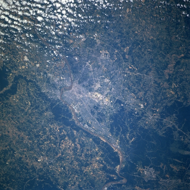
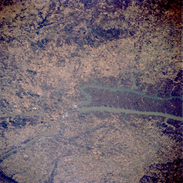
Louisville, Kentucky. Several bridges span the Ohio River, the narrow muddy-looking feature that extends across the image from northeast to southwest. Downtown Louisville is adjacent to the Ohio River just east of the rounded promontory that juts northward into the Ohio River (slightly right of center). Indiana is north of the river and Kentucky is south of the river. Major highways can be traced across the Louisville region. These roads include an inner loop or beltway (Interstate Highway 264) and an outer loop (Interstate Highway 265). Additionally, Interstate Highway 65, a major north-south artery, is especially easy to discern as it enters the south side of the city. A cluster of highly reflective features (center of the picture) shows the location of Standiford Field and a large federal installation. The darker landscape maps the extent of heavily wooded, rugged, undeveloped terrain, located southwest of the urban area. There is also a narrow band of wooded acreage along the north bank of the Ohio River west of Louisville.
Kentucky lies astride the Columbia Plateau, one part of the mountains. From the high forested mountains is slopes westward toward the Central Lowlands. All of the rivers are part of the Mississippi basin. The Mississippi forms the western boundary of the state, just where the Mississippi begins some of its most spectacular meanders. Indeed, the boundary separating Missouri and Kentucky once followed the river and still marks where the river flowed when the state lines were drawn. Since this time numerous man-made cut-offs of the river have made the Mississippi straighter than it used to be. The Ohio, one of the major tributaries of the Mississippi, marks the northern boundary of the state. The state has numerous rivers of which the Kentucky River and the Cumberland River are the largest. In the Appalachians, these rivers, with their steep-sided valleys, isolate one region from another and still make this part of the state inaccessible. The valleys in the mountains are steep and forested. The history of the rivers, and the reason they flow west, when the grain of the land is north-south can be explained by the fact that the rivers were already flowing from east to west when the Appalachians rose up across their path. The result has been a number of spectacular 'water gaps' where rivers cut right through mountain ranges creating spectacular gorges. The Cumberland Gap is the most famous and historically important of the water gaps in Kentucky, although it is no longer occupied by a river. Kentucky also has large areas of limestone rocks which result in considerable underground drainage and the formation of many caves. Mammoth Cave National Park is the most famous of these. Overall, there are 5000 kilometres (3000 miles) of navigable waterways in the state, of which by far the most important is the Ohio. Many tributaries drain from the Appalachians to the Ohio. The Big Sandy flows through the eastern most part of the state. The basin to the west is drained by the Licking which flows into the Ohio at Cincinnati. The Kentucky River flows through Frankfort to Carrollton on the Ohio, having been formed by the North, Middle and South Forks near Beattyville. The lowest section of the river has been controlled by a series of locks that provide a year round navigation channel. The Green and Barren rivers cut into the Pennyroyal Plateau and form the drainage basins west of the Kentucky. The southernmost of the rivers is the Cumberland. This river, whose headwaters lie in the Cumberland plateau, flows southwestward, entering Tennessee, then turns north to reenter Kentucky to join the Ohio. The highest waterfall in the state is the Cumberland Falls, which has a fall of 21 m (63 feet) near Corbin. The Cumberland is dammed to make Lake Cumberland about half way along its course. It is also dammed in its lower reaches by the Wolf Creek Dam, producing Lake Barkley. The land between Lake Barkley and Kentucky Lake on the lower Tennessee (impounded by the great Kentucky Dam) - called Land Between The Lakes - is a national monument and wildlife refuge (Kentucky Woodlands Wildlife Refuge). The Tennessee River flows into Kentucky in the southwestern corner of the state, paralleling the Cumberland River. The two rivers are connected by a 2.5 kilometres (1.5 miles) canal. The Ohio has dominated trade in Kentucky, resulting in most of its largest population centers being situated on the river. Louisville is the largest city in Kentucky. Covington, the fourth-largest city in the state, is situated directly across the Ohio River from Cincinnati. Owensboro is the third-largest city and also a port on the Ohio River. Paducah is also a port on the Ohio.
Kentucky Lake and Lake Barkley, Kentucky, U.S.A. The northern ends of two long reservoirs, Kentucky Lake and Lake Barkley, are visible in this northwest-looking, low-oblique photograph of western Kentucky. Westernmost Kentucky Lake is fed by the Tennessee River; Lake Barkley is part of the Cumberland River drainage basin. Each lake has a dam and channel that allow water to flow into the Ohio River, which makes a U-turn at this location. The heavily wooded peninsula between the lakes is called locally "the land between the lakes." Both lakes are under the aegis of the Tennessee Valley Authority, which was created to provide hydroelectric power, improve navigation of the rivers, and reduce flooding on the Tennessee and Cumberland Rivers and some of their tributaries. Most of the region east of the lakes is hilly; west of the lakes the landscape becomes a plain. |
For more detail on specific rivers in the United States click this link