|
The Delaware at Bethlehem.Length: 650 kilometres (450 miles); drainage basin: 30,000 square kilometres (11,400 square miles) The Delaware River flows southward through the Northeastern United States. Its headwaters are in the Catskill Mountains of New York State. The twin headwater rivers called the East Branch and West Branch meet near Hancock, New York to make the Delaware River. From here to the sea is a river distance of about 450 kilometres (280 miles). The main, or West Branch, begins some 580 m (1900 feet) above sea level. The Delaware flows south from New York State, along the boundary with New Jersey, Pennsylvania and then to Delaware, where, in Delaware Bay, it enters the Atlantic Ocean. The main tributaries are: Schuylkill and Lehigh in Pennsylvania, the Neversink in New York, and the Musconetcong in New Jersey. The Delaware is a substantial enough river to be used as the state boundary between New Jersey, New York and Pennsylvania as well as the boundary between New Jersey and Delaware. For much of its length, the Delaware River flows in the Appalachian Mountains, keeping roughly aligned with the folds, which run north to south. However, in the sandstones of the 450 m (1400 feet) high Kittatinny Mountains the Delaware has formed the gorge known as the Delaware Water Gap about 360 m (1200 feet) deep and 1.6 kilometres (1 mile) wide. This gap, just east of Stroudsburg, Pa, is an example of superimposed drainage, the course of the river being formed on rocks long eroded away. It became important because it was one of the few gaps that allowed people to explore westward during the early years of colonization. In flowing southward, the Delaware flows across the grain of the land, whose mountain ridges and valleys run from south to north. To achieve this feat, therefore, the Delaware has had to cut gaps through the mountain ridges. The most important, and best known of these gaps is the Delaware Water Gap. The Delaware continues to run through the Appalachians as it continues south. A particularly dramatic part of this section is the cliffs called the Nockamixon Rocks, some 5 kilometres (3 miles) long and 60 m (190 feet) high. The river reaches sea level and becomes tidal at Trenton, the capital of New Jersey, some 200 kilometres (130 miles) from the sea. This lower section, which includes the Pennsylvanian capital of Philadelphia and the industrial city of Wilmington, Delaware, is very different from the mountain tract, and the river is broad and slow-flowing. In this section the river becomes navigable for the first time and the lower Delaware carries more than three quarters of the tonnage that goes down the Mississippi, making it the nation's second most important commercial river artery. The river is continuously dredged to ensure that there is sufficient water for ocean-going tankers. HISTORY The first European to reach the Delaware was Henry Hudson in 1609. By 1610 the river had been named for Lord De La Warr, the governor of Virginia. Although it was found and named first by the English, it was in fact the Dutch and Swedes who first settled on the banks of the Delaware. Signs of this can still be found in the place names. For example, the tributary called the Schuylkill is a Dutch word meaning 'hidden river'. By 1664, the English had colonized the whole region, and by 1682, William Penn, the English Quaker, had been granted the land to set out the planned town of Philadelphia (the city of brotherly love). During the American Revolution, the Delaware became a strategically important line of defense. On Christmas night of 1776, George Washington and about 2,400 of his soldiers crossed the Delaware just north of Trenton and overwhelmed the British troops stationed at Trenton. Washington again crossed the Delaware in order to win the battle of Princeton. The lower course of the Delaware is a historically important industrial area, much of it occurring in the 80 kilometres (60 miles) tidal stretch of the river between Trenton, New Jersey, through Philadelphia, Pennsylvania, to Wilmington, Delaware. Throughout the 18th and 19th centuries, industrialists were acutely aware of the importance of navigable rivers to carry their goods. They would even go to extraordinary lengths to make waterways where they did not conveniently exist. The most important canals were the Trenton to New Brunswick, which connected the Delaware and Raritan rivers, and the 30 kilometres (20 miles) canal that joins the Delaware River with Chesapeake Bay. The Chesapeake and Delaware Canal has stood a century and a half of use. The Chesapeake and Delaware Canal was built as a private venture and opened in 1829. However, by 1919 the federal government purchased the canal. It was subsequently converted by the U.S. Army Corps of Engineers to a free-flowing waterway and is still among the world's busiest canals. This is the only canal still used for transport. The Delaware Raritan canal is now used as an aqueduct to supply water to Princeton, New Jersey. In fact, this short stretch of river is far less industrialised than it was half a century ago, when factories still lined the banks and discharged polluted waters into the river. Today, much of this obviously riverside industry has gone, the factories and warehouses abandoned or demolished. Yet the Delaware still carries substantial cargoes, and in terms of river tonnage carries about three quarters as much as the Mississippi. The main port areas of the Delaware are at Wilmington and Philadelphia. Here the river is large enough for supertankers to berth. The arrival of bulk goods such as oil has given the Delaware the first position as a river of imports to the United States. All of the industrialization has resulted in a history of severe river pollution. The Delaware River Basin Commission was set up to try to ensure that the river water becomes cleaner each year and that abandoned areas become revitalized. The Philadelphia District owns and operates five flood control projects within the Delaware River Basin. These projects are located in the Lehigh, Lackawaxen and Schuylkill River Basins. An underground aqueduct carries water from the Delaware in the Catskills to provide part of New York City's water supply. It is called the Delaware Aqueduct and flows through a rock-blasted tunnel up to 6 m (20 feet) across for 140 kilometres (85 miles) beginning at the Rondout Reservoir in the Catskills and ending in the Hill View Reservoir in southern Westchester and an extension carries it to Hillview Reservoir in Yonkers. In some places the aqueduct is 830 m (2500 feet) below ground. This system works entirely on gravity and no pumps are used. It carries 4.5 billion liters (1.2 billion gallons) per day. The Delaware system is part of the largest water supply system for any single city in the world. Water from other parts of the Delaware Basin are taken through the Neversink, East Delaware, and West Delaware tunnels. Delaware Bay is 85 kilometres (52 miles) long. It begins at Cape May and reaches inland to where the Delaware River meets the Alloway Creek. The sides of the estuary are tidal marshes. The dredged channel leading to Philadelphia is deep, 10 m (33 feet) and 180 m (600 feet) wide.
Flood control and other measures are the responsibility of the U.S. Army Corps of Engineers. There are many areas of historic and scenic interest on the Delaware. They include the Delaware and Hudson Canal operated by the National Park Service. |
|
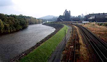
More details of the Delaware and tributaries Bethlehem Bethlehem is one of the oldest industrial towns of North America. Situated on the Lehigh river, a tributary of the Delaware, it was once one of the most famous and influential iron and steel works in the world. Such was the power of the steel works in the past that the transport costs of all steel freight in the U.S. had to be priced as though it had been made in Bethlehem. This gave rise to the Bethlehem Plus system, designed to prevent competition from other steel manufacturers. The steelworks was situated on the river both for transport and for the use of cooling water. Times have changed, however, and the steelworks has now been decommissioned.
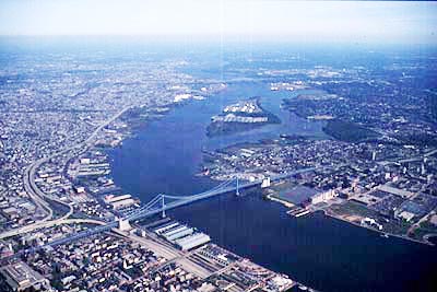
Philadelphia lies at the confluence of the Schuylkill and the Delaware rivers. This aerial picture shows much of the city.
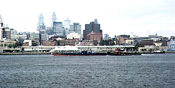 This picture of the city is of the Delaware side and is taken from Camden. The largest dock area was developed here. Not many bridges cross the Delaware. This is the George Washington Bridge, the main bridge connecting Camden (right) and Philadelphia (left). |