|
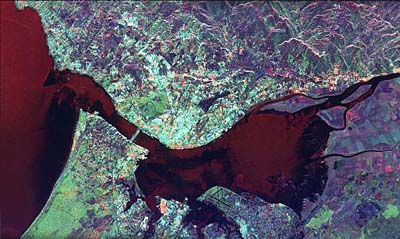
The Tagus in Lisbon. This false color picture was taken by a satellite.
The Tagus, which flows through central Spain and Portugal, is the longest river in the Iberian peninsula. Its headwaters are in eastern Spain in the Sierra de Albarracin mountains. It then flows west for about 1000 kilometres (600 miles) to reach the Atlantic Ocean near Lisbon. It drains an area of about 82,000 square kilometres (32,000 square miles). Much of the climate of the Tagus basin is influenced by being close to the Mediterranean Sea. The mountain lands are forested with conifers, but except close to the rivers, much of the land is semi-arid scrub. In the head-waters, the Tagus flows through limestone country in a deep, steep-sided gorge. The landscape is barren and intensely hot in summer. It leaves the limestone at Trillo and the valley opens out and the river begins to meander freely. The need for water in this part of Europe has meant that the Tagus is trapped as soon as possible. There are two dams near Bolarque, which form the 130 square kilometres (50 square miles) reservoir called the Sea of Castile. These are just two of over 60 dams in the Tagus basin which together provide both irrigation water and hydro-electricity. The river waters are used for irrigation in the summer. More water is taken from the Tagus as it flows down to Toledo and Talavera de la Reina. Then the valley narrows again due to the presence of hard bands of rock. This provides the opportunity for more dams and reservoirs. At Puente de Alcantara the dam has impounded a lake 90 kilometres (50 miles) long. Below the dam the river forms the frontier between Spain and Portugal and then flows into Portugal at Beira. From here it flows through central Portugal to Lisbon and the sea. The Tagus is only navigable in its lower reaches.
Cities on the TagusToledo (Spain) Santarem (Portugal) Lisbon (Portugal) |