|
Location: 54N 10E (Germany); length: 1100 kilometres (700 miles); drainage basin: 144,000 square kilometres (56,000 square miles).
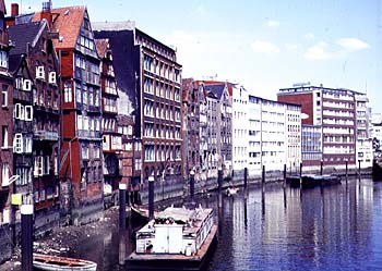
The old harbour in Hamburg.The Elbe is one of Europe's most important rivers, flowing north and west from its headwaters in the Sudeten Mountains of the Czech Republic to the North Sea at Hamburg in Germany. The most important cities on the Elbe include Prague (Czech Republic), Dresden, Magdeburg and Hamburg (Germany). Tributaries include the Havel and Spree. For most of its length, the Elbe is a lowland river, meandering across a landscape of glacial deposits on the North European Plain. The Elbe is the most important navigable river in northern Europe. Vessels can reach 800 kilometres (500 miles) upstream from the port of Hamburg, carrying a wide variety of bulky and heavy cargoes. The Elbe traffic was very restricted for forty years because, just a few kilometres upstream of Hamburg it used to be entirely in communist Europe. This cut off Hamburg from its natural trading area (hinterland). Now that the 'Iron Curtain' no longer exists, trade is increasing again. The Elbe is linked with the Rhine by canal including the Mittelland canal through the Ruhr region of Germany and to Berlin by the Elbe-Havel canal. It is also connected to the Baltic Sea by the Elbe-Lubeck canal. In 1977 The basin of the Elbe was subject to months of torrential rain with the result that large areas of the floodplain were turned into Europe's largest lake. Many thousands of people were made homeless throughout the summer. |